How to use Cherokee Place Names

We suggest that you click on the Index button above.  That will open up a useful starting place with partial lists of the many place names in the blog.  There are links to specific sections containing a given group of names so that you can quickly locate information about each one. Note that there is also a “Search” function on the upper left of this and other pages.  You can use it to search this site for any word you wish.  [Unfortunately, for the mobile version, one must scroll all the way to the bottom of a section to find the search function.  The search function on the mobile version can be most quickly located by going to the Index section or the About section.  They are much shorter than the Home section, and you will be able to scroll very quickly to the bottom of each of them to find the search button.  Any search button you find anywhere on the site will search the entire site.]

You may also find the About section worth browsing.  It contains links to a number of interesting external sites, including spoken Cherokee samples  and Amazing Grace sung in Cherokee. Your comments are always welcome. We send a special greeting to the Rabun County [GA] Historical Society.  They seem to have one of the best organized county historical websites in the old Cherokee country.

To make the content of this blog more widely available, the materials in it have been reorganized, extended, and provided with more illustrations and maps to create a Kindle version, which can be read on any tablet or computer with an installed Kindle reader.  The e-book has a table of contents with hyperlinks to the chapters and a list of illustrations, also with links.  There are a few internal links for cross-references, and there are external links for additional reading and research. There is an extensive index, but the items in the index do not have links because many items occur in more than one place.  Searching from the index can be done with the normal Kindle or other reader’s  search function.   The illustrations are in full color when a color-enabled e-reader is used. The book, now in its second expanded and enlarged edition [as of 23 February 2013], can be found at this link on Amazon.  It is speech-enabled, and I am impressed with how much that technology has advanced.  The voices are no longer robot-like and they generally pronounce English words and  sentences quite well.   However, the pronunciation of Cherokee words is less than perfect, as would be expected.   [Note that the Eastern Cherokee Treaty Signers pages are not included in the book.] [The price has been set at $2.99.] Thank you for your interest in Cherokee Place Names.

Eastern Cherokee Treaty Signers

It is useful to see the names of the Cherokee men who signed the various treaties made specifically with the Cherokee by the United States, beginning in 1785.  The names of some of the signers have become place names in the southeastern United States.

So that we can look at the signers’ names, I have arranged the treaties chronologically, and I have listed the signers for each treaty alphabetically by the first word of each name.   For perhaps obvious reasons, I have chosen to omit the Treaty of New Echota [1835], because this false treaty was signed by a group of Cherokee who were not authorized representatives of the tribe, and which formed the spurious legal basis for the Removal [“Trail of Tears”].  See this page for details of the Removal.

Because this list is long, please note the page numbers at the bottom of each page.   Click on the next page number to continue.

The majority of the Cherokee signers were not literate in English and the Cherokee had no written language until the early 1820s.  Signing was usually done by “his mark,” normally an “X.”   Because the name of the signer had to be written down beside his mark, it was mostly white people who had the task of creating some reasonable spelling of the Cherokee names.  The results were often quite strange, variable, and difficult to decipher even by one who knows a great deal about the Cherokee language.  Different transcribers often had quite different spellings and some of the transcribers—in my opinion—probably were very poor spellers in English, with distorted notions of how sounds should be written.  We all tend to hear sounds of some foreign language differently anyway. [Hobson-Jobsonism: altering foreign words or expressions to fit the speech and spelling patterns of another language, in this case, English.] Moreover, perhaps some of the transcribers may have been Cherokee or other Indians who also served as witnesses or even as signers and whose command of written English was less than perfect.

A good example of variability comes with the name Wyuka on the Treaty of Hopewell.  The same chief appears as Skyuka on the Treaty of Holston [1792] and the Treaty of Philadelphia [1791].  His name in Cherokee was probably Kiyuga, which retains its meaning as chipmunk, which we in the mountains call “ground squirrel” in English.

In a future post, I will provide more information about the meanings of some of the names of the signers, but, for now I will avoid making any notes directly in this list.

Treaty of Hard Labour, 1768

Chinistoe

Conanennah

Cotchatoy

Ecuy

Mankiller of Chote

Otacite of Quaratrie

Oucconnastotah

Raven of Newcassie

Raven of Tugaloo

Saliey

The Wolf of Keowee

Tiftoe

Tuckassie Keowee

Usteneca

Warrior of Cowie

Willinawaw


Treaty of Lochaber, 1770

Altahkullakulla

Chinista

Chinista Watoga

Chukamuctas

Ecuij

Kaheatoy

Kinnatitah

Kittagusta

Otacite of Higwassie

Oucconnastotah

Skaliloske

Tarrapin

Teutchkee

Tiftoy

Uka Youla

Wolf of Keowee


Treaty of Hopewell, 1785

Akonoluchta, the Cabin

Amokontakona, Kutcloa

Cheanoka, of Kawetakac

Chescoonwho, Bird in Close of Tomotlug

Chesecotetona, or Yellow Bird of the Pine Log

Chesetoa, or the Rabbit of Tlacoa

Chokasatahe, Chickasaw Killer Tasonta

Chonosta, of Cowe

John, of Little Tallico

Keukuck, Talcoa

Kolakusta, or Prince of Noth

Konatota, or the Rising Fawn of Highwassay

Kostayeak, or Sharp Fellow Wataga

Kowetatahee, in Frog Town

Lach’n McIntosh Koatohee, or Corn Tassel of Toquo

Necatee, of Sawta

Newota, or the Gritzs of Chicamaga

Onanoota, of Koosoate

Ookoseta, or Sower Mush of Kooloque

Ooskwha, or Abraham of Chilkowa

Scholauetta, or Hanging Man of Chota

Skeleak

Sketaloska, Second Man of Tillico

Tatliusta, or Porpoise of Tilassi

Toostaka, or the Waker of Oostanawa

Tuckasee, or Terrapin of Hightowa

Tuckasee, or Young Terrapin of Allajoy

Tulatiska, of Chaway

Tulco, or Tom of Chatuga

Tuskegatahu, or Long Fellow of Chistohoe

Umatooetha, the Water Hunter Choikamawga

Unsuokanail, Buffalo White Calf New Cussee

Untoola, or Gun Rod of Seteco

Will, of Akoha

Wooaluka, the Waylayer, Chota

Wyuka, of Lookout Mountain

Yellow Bird

Cherokee counties . . .

There are eight Cherokee counties in the United States.  Seven of them have historical connections with the Cherokee people. As found in hundreds or thousands of business names, personal names, automobile models, and much more, the name “Cherokee” is greatly overused, more or less indiscriminately.  If it were possible for them to collect royalties on such usage, the three recognized Cherokee tribes would together be one of the wealthiest entities on the planet.  The Cherokee are probably the best-known worldwide of all American Indian tribes. I am going to refrain–wisely, I think–from commenting on the enormous number of Americans who insist that they have Cherokee ancestors.  And, I will have nothing to say here about the 212 groups, at last count, who declare that they are unrecognized Cherokee tribes and remnants. In modern Cherokee, the word is Tsalagi.  In the now extinct Lower Cherokee dialect, it was Tsaragi, and it was from this dialect that the name was anglicized to “Cherokee.” Although Tsalagi is not a Cherokee word, it is now the self-designation of the members of the tribes.  Its origin is uncertain, but I am inclined to agree with those who believe it may have come from Choctaw, probably from a term meaning either “people who live in the mountains” or “people who live in cave country.” Here are those eight counties, alphabetically by state name, with a brief explanation of how each one acquired its name. Cherokee County, Alabama, was formed from Cherokee lands soon after the Treaty of New Echota was signed, more than two years before the Trail of Tears. Cherokee County, Georgia. Originally, most of northwest Georgia, which then belonged to the Cherokee, was simply designated late in 1831 as that state’s Cherokee County.  Within a year, it was carved into nine new counties, and, toward the end of 1832, the Cherokee lands were distributed by lottery to white people.  Some of the Cherokee were already being forcibly removed by Georgia in 1831, years before the falsely promulgated Treaty of New Echota.  The remnant after the other nine counties were created—and a part of it used to form Milton County in 1857—is the present Cherokee County.  To be historically blunt, the State of Georgia was the most brutal of all states toward the Cherokee. Here are maps of the Cherokee lands in Georgia in 1822 and in 1834. Cherokee County, Iowa, lies in the northwestern part of the state.  It was one of many formed from “Indian Treaty Lands” in 1851.  The name seems to have been chosen because the Cherokee had no connection at all with the area.  More details about the historic and prehistoric Indians of Iowa can be found in the Wikipedia article Indians of Iowa.

Cherokee County, Kansas, is the extreme southeastern county of Kansas, bordering Craig County, Oklahoma.  Craig County was formed from a part of the Cherokee Nation when the Indian Territory became a state in 1907.   Some Cherokee people lived in that part of Kansas beginning in the 1830’s.

Cherokee County, North Carolina, is the westernmost county of the state.  It is near the heart of Tsalaguwetiyi [ᎠᎳᎫᏪᏘᏱ], the old Cherokee lands.  There are tracts of the Eastern Cherokee trust lands  [the Qualla Boundary and non-contiguous parcels] in the county, and it has a significant modern Cherokee population.  I would rate it as the most deserving of all the counties bearing the name. [The main part of the Eastern Cherokee trust lands is located in Swain and Jackson counties, with outlying parcels in Cherokee, Graham, and Haywood counties.  The Qualla Boundary is sometimes called a “reservation,” but that is not a correct designation.]

Cherokee County, Oklahoma, is at the heart of the Western Cherokee country, formed from a part of the Cherokee Indian Nation, Indian Territory, shortly before Oklahoma became a state.  The county seat, Tahlequah, is the capital of the Western Cherokee Nation today.  A little more than one-third of the population of the county are American Indians.

Cherokee County, South Carolina.  There were some Cherokee [and Catawba and other Indians] using the lands in this area when the white people moved in and pushed them away beginning in the middle of the 18th Century.

Cherokee County, Texas, adjoins the northeastern line of Houston County.  It has a complex and sad history of Cherokee settlers and their unfulfilled hopes.  You can find more details of that history here.

How Did Sequatchie Valley Get Its Name?

Please note:  The following entry is highly tentative and is subject to substantial revision as more research is completed.  After it was written, I have discovered a very old map which shows a town “Sequache.” [John Herbert’s map of 1744] [A new mapp of his maiestys flourishing province of South Carolina : shewing ye settlements of y[e] English, French and Indian nation / Jn. Herbert]  Here below is that map, and following the map is an enlarged section of the map showing Sequache a little to the right and slightly below the center.  [Enlarge either map for better viewing by left-clicking on it.]

Herbert Map 1744 Full

Herbert Map1744 enlarged

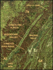
Google Earth reveals a remarkable and prominently visible valley, some 150 miles long, almost unnaturally straight, only three to five miles wide, extending from west of Knoxville southwestward to Blount County, Alabama.  The part in Tennessee is called the Sequatchie Valley; the Alabama portion is known as Brown’s Valley.  The satellite photo here is one made by NASA.

SequatchieValley

The Sequatchie River originates in southern Cumberland County, Tennessee, and meanders from side to side within the valley for a good part of the valley’s length, until it empties into the Tennessee River just west of Chattanooga.  Were the river stretched out straight, it would likely extend for well over 200 miles, but, because of its tortuosities, it traverses not quite the entire Valley within Tennessee and none at all in Alabama, of course.  Officially, it is reported to be 116 miles long, but even that figure incorporates most of the major meanders in its determination.

Before the Valley had been studied more authoritatively, it was believed to be a rift valley, which would have made it all the more remarkable.  Geologists have long since determined that it is actually an eroded anticline.  Either case would have explained the sometimes very steep escarpments on either side of the Valley.  As so often happens with other errors in every field, the designation as a rift valley [“one of only two on the planet”] has been copied into succeeding works and is still found in many references today.

Our interest lies in the word Sequatchie.  How came the Valley and the River to have this name?   And, therein we find other problems.

Mooney declares that the River—and therefore, the Valley—takes its name from a traditional Cherokee settlement on the south bank of the French Broad River, near the point at which the French Broad joins the Holston to form the Tennessee River.  In this case, I think by “traditional” he means that there must have been some memories of stories of such a place among older Cherokee people in the late 19th Century.  To this date, I have not been able to find any old maps or other historical sources to verify its precise location, and I have examined dozens of them.  He says that the name of the ancient town was Sigwetsi.  A map showing Frankliniana [eastern Tennessee] in 1813 shows no sign of the settlement or even of the large Valley.  An 1814 map has at least some hints of the Valley, but no name is applied to it, and a 1756 map seems to show it, also without a name.  One 1775 map shows a river corresponding to the location of the Sequatchie River; it is labeled the “Salecook” River.  [Salecook is probably an English attempt at “saligugi,” the Cherokee word for the common snapping turtle and the alligator snapping turtle of the Southeastern US.]

Chambers of commerce and historical sites in the region say the Valley was named for the Cherokee “chief” Sequachee or Sequatchie, who “signed the Turkeytown Treaty” of 1817, or who “signed a treaty with colonial South Carolina.”  I have found no such signer for any treaty involving the Cherokee.  If he signed any treaty, it must have been a very obscure one; however, I am continuing the research, and I will report the error if I am wrong.  Personally, I doubt that there was ever a “Chief Sequachee” who signed any treaty.  If I prove to be wrong, I will own up to it.

In the 1835 Henderson Roll, the last census of the Cherokee in the East before the Trail of Tears, there does appear one Sequahchee, who lived in Georgia.  He had no traceable connection with the Valley, and I feel quite sure that it was not named for him or his family.  He probably was removed to Oklahoma during the Trail of Tears.

[On that same roll, we find the name Sequegee, at least some of whose family survived the Trail of Tears, and whose modern descendants are the Sequichie family of Oklahoma.  Joyce Sequichie Hifler is a well-known author and columnist who has written nine inspirational books with Cherokee themes.]

Let’s see if I can assemble what I have learned from some intensive research into a plausible whole.  The following is much more speculative than is my usual practice, and it is subject to argument and correction if later research proves it highly unlikely.

The Knoxville area was first settled by whites in the 1780s.  Cherokee people living there knew about the old village of Sigwetsi, and perhaps some of it even remained intact.  I suspect that the town did not come into being until after the Spanish explorers passed through.  I will explain that reasoning shortly.

From the vicinity of old Sigwetsi, a trail developed to the west through what is now Kingston to the head of Sequatchie Valley.  The route came to be called informally “the Sequatchie road.”  English speakers spelled it more or less that way in letters and documents, some written in the early 1800s.  Because the Sequatchie road led to the Valley, it was only natural for the Valley to become the Sequatchie Valley.  I can’t prove all of this, but there are enough indications from old letters and documents to provide some support for my conclusions.

Now, having settled that, let us see what the meaning of Sigwetsi was likely to have been.

The Cherokee had never seen hogs before the Spanish explorers came, so they used the word for opossum (si’qua) as a name for them. That left them with the necessity to distinguish ‘possums from pigs, so the ‘possum came to be called “siqua utsetsidi,” the “grinning pig,” a short form of which is “siqua-utsets.” Nowadays, only the grin is left, and the possum is just “utsetsidi” [pronounced roughly “oo-chets’-dee,” depending on the dialect].  Sigwetsi is merely a shortened form of “siqua utsetsidi.”  Such shortenings are common in Cherokee.  The shortened form would have been accented on the –qua- element, becoming roughly “siQUAchets.”   And that became Sequatchie in the white man’s pronunciation.

Sigwetsi, then, was Mooney’s best approximation of the name of the settlement, and the village name is likely to have meant “Opossum Place” to the Cherokee who lived there.  That’s ” ‘Possum Town” to you and me.

You may be sure that my research into the origin of Sequatchie will continue.

The Turkeytown Treaty

From 1721 through 1868, the Cherokee people had more than forty treaties with the white people, at first with the British and colonists and later with the American government.  So far as I can tell, all of them seem to have been broken.

One that is of interest to us here in dealing with place names of Cherokee origin is the Treaty of 1817, also called the Treaty of the Cherokee Agency.  There had been, in 1816, two other treaties which, as usual, required the Cherokee to cede more lands.  In March of that year, they had ceded all remaining lands in South Carolina,  a small section in and around what is now Oconee County.  In September, the tribe in a general meeting at Turkeytown [Alabama] had ratified the Treaty of the Chickasaw Council House, ceding most of their lands in Alabama and nearby border areas, some 3,500 square miles.

On 8 July 1817, the Treaty of the Cherokee Agency was signed by 31 Cherokee leaders from North Carolina, Tennessee, Georgia, and Alabama, and by 15 Arkansas Cherokee chiefs, as well as by Major General Andrew Jackson—he did not become President until 1829—and by Governor McMinn of Tennessee.  It is often somewhat erroneously called the Turkeytown Treaty.  Including the Arkansas chiefs constituted the first formal recognition of the Western Cherokee.  Most of the Cherokee bitterly opposed this treaty and that of 1819.

Together with the Treaty of Washington in 1819, the Cherokee Nation ceded almost all their remaining lands in the East, except for northwest Georgia and some adjacent lands in Tennessee, Alabama, and the extreme western part of North Carolina.  The details of the cessions can be found in the map at this link.

A key provision of the Treaty of 1817 that came to affect some place names was Section 8:

“And to each and every head of any Indian family residing on the east side of the Mississippi river, on the lands that are now or may hereafter be surrendered to the United States, who may wish to become citizens of the United States, the United States do agree to give a reservation of six hundred and forty acres of land in a square to include their improvements which are to be as near the centre thereof as practicable, in which they will have a life estate with a reversion in fee simple to their children reserving to the widow her dower, the register of whose names is to be filed in the office of the Cherokee agent, which shall be kept open until the census is taken as stipulated in the third article of this treaty [June 1818]. Provided, That if any of the heads of families, for whom reservations may be made, should remove therefrom, then, in that case the right to revert to the United States. And provided further, That the land which may be reserved under this article, be deducted from the amount which has been ceded under the first and second articles of this treaty.”

The treaty promised a square mile of land to every Indian family east of the Mississippi River living on the lands that were ceded to the government if they would become citizens of the United States and give up their status as Cherokee [or other] Indians.  Six hundred forty acres for their very own, with their present home as nearly as possible to the center of that acreage–that was the promise.  All they had to do was file a request with the Indian Agent within almost a year.  Very few of the people had ever owned any land, and the concept was somewhat foreign to them.  Perhaps the main attraction for becoming “citizen Indians” may have been staying in the East, on familiar lands.  Only about 311 Cherokee people applied for the land.  A few of those actually got some land, usually less than the promised amount, and almost all of them lost what they did get.  Still, for a time, some of them remained among the white settlers.

Without going into historical details about the frustrations and thwarting of the allotments, we can see what effects some of these citizen Cherokees had on local place names.  [If you would like to examine some of the efforts by the states to deprive the Cherokee of the promised allotments, you could read the efforts of the state of Tennessee, which were probably typical of most of the states involved, possibly excepting North Carolina.  Georgians were especially inimical to the Cherokee, as later events would prove.]  You can find more depth on Cherokee history at this link.

Cherokee people who applied included The Cat, who lived near Sugartown [Cullasaja].  The creek he lived on is now called Cat Creek.  His name was probably a translation of Gvhe, wildcat, or  it may have been a translation of Tlvdatsi, the mountain lion, which the white settlers called “painter” [panther”].  Wesa was merely a Cherokee attempt at the English word “Puss,” the word used for a domestic cat.

One applicant, Little Betty, lived near the whites a little longer than most.  She was a widow with several children, we are told.  Her reserve was to be at Eastertoy, which later became Dillard, Georgia.  Betty’s Creek is named for her.  I am surprised to see its name showing up with increasing frequency as Betty Creek, an example of the gradual erosion and changing of place names as outsiders move into the mountains of Georgia and North Carolina.  Among people who grew up near Dillard, the name is always pronounced as if it were “Bettis Creek.”

Near Betty’s Creek is Betty Whitecloud Street.  As of now, I do not know if there is any connection with Little Betty, and I am inclined to doubt that there is.

Another applicant was Old Mouse, who lived “below Cowee,” that is, downstream from Cowee [NC].  He is remembered in the names of Old Mouse Creek and Mouse Mountain.  His name is a translation of the Cherokee word talasgewi [or possibly tsisdetsi or tsistetsi], with “Old” having apparently been appended in English.

The reservee listed in application documents as Musk Rat was living on Cartoogechaye Creek [on Ca-tur-as-joy Creek, the document says].  Muskrat Creek, Muskrat Valley, and Muskrat Road are named for him. His English name was a translation of salaquisgi [or salagisgi or selagisgi].

Otter Creek, about halfway between Franklin and Robbinsville, in the Nantahala Community, takes its name from citizen Cherokee Otter.  His name is a translation of Tsiyu.  His neighbor to the northwest was one Taylor Eldridge, white husband of Pathkiller’s daughter Ailcey.  Pathkiller himself had applied for his reserve about 2½ miles above the mouth of Sweetwater Creek, further to the northwest in the same general area.  Otter’s daughter Jane, while working for some of the white settlers, is said to have been killed by a panther [tlvdatsi, mountain lion].  Her name was given to Jane Otter Creek, a tributary of Otter Creek.

In 1818, Eu-chu-lah of Cowee applied for his 640-acre reserve just west of the Cowee Mound, and it seems to have been granted.  In old documents, it is recorded as the Euchella Farm.  It seems to have been taken over by the state of North Carolina almost immediately, whether by sale or by force.  In 1821, 299 acres of it was sold by the state to Joseph Welch.  The name survives in Euchella Cove, Euchella Church, and some other modern developments some miles to the west of the original farm.

About Turkeytown, Alabama:  The present community lies about halfway between Weiss Lake and Gadsden; the historical Cherokee town site, Gvna-digaduhvyi, is under the water of the lake.  The community, Little Turkey Road, and Turkeytown Gap are named for Gvna [or Gvnastee, Gvnusdi], the first Principal Chief of the Cherokee Nation.  His name translates to Turkey [or Little Turkey].  John Ross was born at Gvna-digaduhvyi in 1790, and he was one of the people requesting a reserve under the “Turkeytown Treaty.”

The Curious Tale of Osenappa

For more than forty years, whenever I have had occasion to be in the area, I have lingered for a time at the Old Stone Church Cemetery in Clemson, South Carolina.  For a few years in the 1970’s, I lived not many miles away.  I last visited the cemetery in 2011.

It is strange how a cemetery can evolve over the years, even without considering the new graves that are filled. In the 1970’s, there was no “Cherokee Indian” named Osenappa buried at the Old Stone Church.  Or, at least, I saw no sign of such a thing back then.  Now, one finds these words, taken from the Historical Marker  at the Church and duly recorded in the Historical Marker Database:

“One of the oldest graves is that of Osenappa, a Cherokee, who died in 1794. In addition to the marker, a cairn (piled stones) identifies the grave. He is the only Native American buried here. His role in this South Carolina frontier remains undiscovered.”

And, there is a crudely inscribed stone marker, this one, at the end of a cairn:

Osenappa

As you can see, the marker does not appear to be ancient.  Of course, it may have been merely a home-made replacement for an earlier, vanished stone, made by some person of good will.  I do not know who made it or how it got there. But, it was a replacement for an earlier marker.

The catch is that Osenappa was very probably not a Cherokee Indian.  The Cherokee language does not have any [p] sound at all; it is not a Cherokee name.  My mildly educated guess is that the word is from one of the Muskogean languages, most likely Choctaw.

In January 1935, Mary Cherry Doyle, a descendant of the Reeses, wrote a brief history of the Old Stone Church and Cemetery, apparently for the local chapter of the Daughters of the American Revolution.  Among her descriptions of the graves and their occupants, we find this mention:

A small stone marks the grave of a child. Osenappa Reese, who was said to have been named in honor of an Indian chief, Osenappa, who was kind to the settlers in this vicinity. Here is that stone:

OsenappaReese

Osenappa Reese was the son of George Reese II, and, so far as we know, he was born late in 1829 and died on 4 June 1930 of diphtheria. He was named for the Indian Osenappa.

In the cemetery is buried Rev. Thomas Reese, pastor of the church from 1792 until his death in 1796. He is said to have been the first, or among the first people buried in the cemetery. Nearby is the grave of his brother George Reese, the grandfather of Osenappa Reese.

Little Osenappa, thus a grandnephew of Rev. Reese, was named for the Indian Osenappa. [Old records say that Osenappa was converted to Christianity by Rev. Reese, and that he lived for a time in the manse with the Reese family. Apparently, he died within a year or two of his conversion.]

Did the Indian Osenappa befriend the white settlers in the Pendleton District? Where did he come from, if he was not a Cherokee?

Was there an Alabama connection? A few miles to the south of West Point, on the Georgia-Alabama line, Osanippa Creek empties into the Chattahoochee River [or, rather, into the upper reaches of Lake Harding, formed by a dam on the Chattahoochee].   A coincidence of names?  Perhaps.  Perhaps not.  In older documents from the 19th Century, several of them, the creek’s name appears as Osenappa.   Is it the same name?  Is there a direct connection?  The creek’s name seems to have come from a Muskogean word meaning “moss up high,” perhaps indicating its banks were moss-covered, or it may simply have referred to a tree with a high moss cover.

Curiously, George and Mary Ann Reese, the parents of Osenappa Reese, celebrated their golden wedding anniversary in 1874 at the home of their son Milton E. Reese in West Point, Georgia. Their last residence was Bluffton (now called Lanett), in Chambers County, Alabama.

The Legend of Kanasta

Connestee Falls, NC, takes its name from the lost city of Kanasta.  Here is the legend, taken more or less directly from Mooney’s Myths of the Cherokee. Long ago, while people still lived in the old town of Kana’sta, on the French Broad, two strangers, who looked in no way different from other Cherokee, came into the settlement one day and made their way into the chief’s house. After the first greetings were over the chief asked them from what town they had come, thinking them from one of the western settlements, but they said, “We are of your people and our town is close at hand, but you have never seen it. Here you have wars and sickness, with enemies on every side, and after a while a stronger enemy will come to take your country from you, We are always happy, and we have come to invite you to live with us in our town over there,” and they pointed toward Tsuwa`tel’da [Pilot Mountain, in western Brevard County, North Carolina; altitude 5151 feet]. “We do not live forever, and do not always find game when we go for it, for the game belongs to Tsul`kalu’, who lives in Tsunegun’yi, but we have peace always and need not think of danger. We go now, but if your people will live with us let them fast seven days, and we shall come then to take them.” Then they went away toward the west. The chief called his people together into the townhouse and they held a council over the matter and decided at last to go with the strangers. They got all their property ready for moving, and then went again into the townhouse and began their fast. They fasted six days, and on the morning of the seventh, before yet the sun was high, they saw a great company coming along the trail from the west, led by the two men who had stopped with the chief. They seemed just like Cherokee from another settlement, and after a friendly meeting they took up a part of the goods to be carried, and the two parties started back together for Tsuwa`tel’da. There was one man from another town visiting at Kana’sta, and he went along with the rest. When they came to the mountain, the two guides led the way into a cave, which opened out like a great door in the side of the rock. Inside they found an open country and a town, with houses ranged in two long rows from east to west. The mountain people lived in the houses on the south side, and they had made ready the other houses for the new comers, but even after all the people of Kana’sta, with their children and belongings, had moved in, there were still a large number of houses waiting ready for the next who might come. The mountain people told them that there was another town, of a different people, above them in the same mountain, and still farther above, at the very top, lived the Ani’-Hyun’tikwala’ski (the Thunders). Now all the people of Kana’sta were settled in their new homes, but the man who had only been visiting with them wanted to go back to his own friends. Some of the mountain people wanted to prevent this, but the chief said, “No; let him go if he will, and when he tells his friends they may want to come, too. There is plenty of room for all.” Then he said to the man, “Go back and tell your friends that if they want to come and live with us and be always happy, there is a place here ready and waiting for them. Others of us live in Datsu’nalasgun’yi [see Track Rock] and in the high mountains all around, and if they would rather go to any of them it is all the same. We see you wherever you go and are with you in all your dances, but you can not see us unless you fast. If you want to see us, fast four days, and we will come and talk with you; and then if you want to live with us, fast again seven days, and we will come and take you.” Then the chief led the man through the cave to the outside of the mountain and left him there, but when the man looked back he saw no cave, but only the solid rock. The people of the lost settlement were never seen again, and they are still living in Tsuwa`tel’da. Strange things happen there, so that the Cherokee know the mountain is haunted and do not like to go near it. Only a few years ago a party of hunters camped there, and as they sat around their fire at supper time they talked of the story and made rough jokes about the people of old Kana’sta. That night they were aroused from sleep by a noise as of stones thrown at them from among the trees, but when they searched they could find nobody, and were so frightened that they gathered up their guns and pouches and left the place.

Connestee Falls, North Carolina

This page is in process; some revisions may be made later.  I have also posted the legend of Kanasta [ from which Connestee takes its name], above.

I see that Tellico Village, Tennessee, also has street names of Cherokee origin.

Connestee Falls is a large housing development near Brevard, North Carolina.  It occupies some 3900 acres, with about 1300 homes.  I understand that about half of those homes belong to year-round residents.  There are some 50 miles of paved streets in the community.  Some historical information on the area is found at this link; however, for correct translations of the street names, you should look below on this site.  Those on the otherwise excellent historical site are not always very good.  You might also want to read the comments following my translations here.

What makes Connestee Falls of some interest to us?  Almost all of its streets bear Cherokee names.

I have never visited the community, but I have exchanged information with some local people about it, and I have spent a good deal of time studying the map of its streets.

The street names are taken from the names of historical Cherokee towns or places, plants, animals, birds, and famous Cherokee leaders.

Here, I am going to list the names of all the streets.  For each one, I will give a phonetic spelling that could be used by Connestee residents to help with pronunciation.  The pronunciation is intended to preserve at least the flavor of the Cherokee sounds, but it will be one that can be spoken by modern English speakers; it is not intended to be a perfect Cherokee pronunciation. As often as possible, I try to use some rough approximation of the Giduwa [Eastern Cherokee] Dialect as a starting point, because that is the major surviving dialect in North Carolina.  However, Giduwa is a more conservative form than the somewhat homogenized Western Dialect of Oklahoma and its sounds are sometimes much more difficult for English speakers [and for me to represent here], so, in several cases, the pronunciation given here is closer to the Western speech.

I hope this will be a helpful guide for Connestee Falls residents and visitors.

In many words, the “v” is best pronounced as “un.”  I have chosen to suggest “ch” as a pronunciation of those syllables beginning with “ts”; some speakers actually pronounce the “ts” sound, but most pronounce as “j” or “ch” or even “z.”  Syllables beginning with “tl” or “dl” are most correctly pronounced with a sound best represented by “hl,” but this combination is not always easy for English speakers, so I have usually suggested some similar sound.  [The “correct” pronunciation of “tl” is very similar to the correct pronunciation of the Ll in Welsh Llanfair.]

After the pronunciation, there will be a spelling of the name that would be readable to a Cherokee speaker and which could readily be written using the Cherokee Syllabary.  Please note that the letter “v” is used to represent the sound that is close to the UH in <HUH?>.

The next entry will be an authentic translation or explanation of the name.  There are still a few of the names that I simply cannot decipher into some original meaning as yet, but I will continue the research and update those names whenever possible.

Anyone who wishes to print out this list is welcome to do so.  I would appreciate it if you would mention the source on the printout.

This is the format:

Street name  [best pronunciation] (Cherokee word, by syllables): meaning

Adawehi [ah-DAH-way-hee]  (a-da-we-hi):  Medicine man, magician, conjurer

Adayahi [ah-DAH-ya-hee]  (a-da-ya-hi):  Oak

Adelv [ah-DAY-la] (a-de-lv): Silver, money

Adohi [ah-DOE-hee] (a-do-hi): Woody place, forest

Agaliha [ah-GAH-li-ha] (a-ga-li-ha): It is shining, so: sunshine or moonshine

Ama [AH-ma] (a-ma): Water or salt.  Probably water was intended.

Amacola [ah-ma-KOH-la] (a-ma u-qua-le-lv-yi): An attempt at Amicalola, place where water makes rolling thunder noise.  The name of the famous water falls and state park in Georgia.  Some old maps spelled it Amacola.

Amayi [ah-MAH-yee] (a-ma-yi): In the water

Annakesta [anna-KES-ta]: I am still trying to decipher this one.

Anv [AH-na] (a-nv, modern form a-ni): Strawberry.  Please don’t pronounce it “Ann-vee!.

Atisvgi [ah-ti-SUN-gi]  Still researching this one

Atsadi [a-CHAH-di] (a-tsa-di): Fish

Awi [ah-WEE or ah-WHEE] (a-wi): Deer

Ayugidv [ah-YOO-gi-DUN] (modern yu-gi-da): Hazel or hazelnut

Catatoga [CAH-ta-TOE-ga] (from ga-du-gi-tse-yi): New town or new settlement.  In Macon County, the same word became Cartoogechaye.

Chagee [CHAH-gi] (tsa-gi): Perhaps from tsa-gi, “up the road” or “upstream”; one Cherokee village bore this name.

Cheestoonaya [CHEES-too-NAH-ya] (tsi-stu-na-yi): Crawfish place

Cheowa [chee-OH-wah] (tsi-yo-hi): Otter place

Cherokee [CHER-o-kee] (tsa-la-gi): the Cherokee people

Cheulah [CHEW-la] (tsu-la): Red Fox, the name of a Cherokee chief in TN, 1762.

Connestee [KAH-na-stee] (ka-na-stv-yi): Meaning unknown; there is a legend of a lost Cherokee settlement from which the name comes.  It is quite possible that it is only a Cherokee approximation of the name of the tribe or town which was there long before the Cherokee arrived.

Dalonigei [da-LAHN-i-GAY-ee] (da-lo-ni-ge-i): Yellow, gold; the same word that became the name of Dahlonega, GA

Dawatsila [DAH-wa-CHEE-la] (da-w-tsi-la): Elm

Dewa [DAY-wa or TAY-wa] (te-wa): Flying squirrel

Dotsi [DAH-chee] (do-tsi): A kind of water monster believed to live in the Tennessee River

Dotsuwa [doe-CHEW-wha or toe-CHEW-wha or toe-JEW-wha] (do-tsu-wa): Red Bird, Cardinal

Doyi [DOE-yee] (do-yi): Beaver

Dudi [DOO-dee; I prefer TOO-tee] (du-di): Snowbird

Duya [DOO-ya; I prefer TOO-ya] (tu-ya): Bean

Dvdegi [DUN-day-gi] (tlv-de-qua): Eel

Dvdisdi [dun-DEES-ti] (attempt at tlv-ti-sdi): Pheasant

Dvga [DUN-ga; I prefer TUN-ga] (tv-ga): Housefly

Echota [eh-CHOE-ta] (i-tsa-ti): Meaning unknown; New Echota was the capital of the Cherokee people at the time of removal.  Sautee is one rendition of the same word.

Elaqua [eh-LAH-qua] [e-la-qua]:  Still under research

Elseetos [el-SEE-toess]: One source claims that this was the Cherokee name of Mt. Pisgah, Haywood County, NC, but I cannot document that.

Enolah [ee-NOE-la] (i-no-li): Black Fox, a Cherokee chief in the early 19th Century; also, an old name for what is now Brasstown Bald in GA

Gadu [GAH-doo] (ga-du): Bread

Gagama [ga-GAH-ma or ka-KAH-ma] (ga-ga-ma): Cucumber

Galuyasdi [ga-LOO-ya-stee] (ga-lu-ya-sdi): Ax or tomahawk

Galvloi [gah-la-LOW-ee] (ga-lv-lo-i): Sky

Ganohenv [GAH-no-HAY-na or KAH-no-HAY-na](ga-no-he-nv): Hominy, which is not the same thing as grits!

Gasga [GAHSS-ga or GOSH-ga] (a-ga-sga): It is raining

Gawanv [ga-WOE-na or ka-WOE-na or ga-WAH-na] (ka-wo-ni): Duck

Gigagei [gi-ga-GAY-ee] (gi-ga-ge-i): Red

Gili [ghee-LEE or GHEE-hli or GI-li] (gi-tli): Dog

Gogv [KO-ga or GO-ga] (go-gv): Crow

Golanv [KO-la-na or GO-la-na] (go-la-nv): Raven; Cherokee name of Sam Houston

Guledisgonihi [GOO-lay dis-KAH-ni-hee] (gu-le-di-sgo-ni-hi): Mourning dove [literally, “he cries for acorns”]

Guque [kuh-KWAY or guh-KWAY] (gu-que): Bobwhite quail

Gusti [GOOS-tee or GUS-tee] (gu-sti): Meaning unknown, from a Cherokee settlement on the Tennessee River in TN

Gusv [goo-SUH) (gu-sv): Beech tree [probably]

Guwa [KOO-wah or GOO-wah] (gu-wa): Mulberry tree

Gvhe [GUN-hay or GUH-hay] (gv-he): Bobcat

Gvli [GUN-tlee or GUH-lee or GUH-hlee] (gv-li): Raccoon

Hokassa [ho-KASS-a] (perhaps intended for na-qui-si): Naquisi is the word for star.

Inadv [EE-na-DUH or ee-NAH-da; EE-na-DEE in some dialects] (i-na-da): Snake

Inoli [ee-NO-lee] (i-no-li): Black Fox; see Enola

Isuhdavga [ee-SUN-da-UN-ga] (i-sv-da-v-ga): Still under research

Iya [EE-yah] (i-ya): Pumpkin

Junaluska [JOO-na-LUS-ka] (tsu-nu-la-hv-sgi): “He keeps on trying unsuccessfully”; the name of a great Cherokee chief in the early 19th Century

Kalvi [ka-LUN-ee or ka-LUH-ee] (from di-ka-lv-gv-i): East

Kanasdatsi [KAH-na-STAH-chee] (ka-na-sda-tsi): Sassafras

Kanasgowa [KAH-na-SKOE-wa or KAH-nahs-GO-wa] (ka-na-sgo-wa):  Heron

Kanunu [ka-NOO-na] (ka-nu-na): Bullfrog

Kanvsita [kah-na-SEE-ta] (ka-nv-si-ta): Dogwood

Kassahola [KAHSS-a-HO-la or KASS-a-HO-la] (ka-sa-ho-la): Still under research

Kawani [ka-WAH-ni or ka-WOE-ni] (ka-wa-ni): Perhaps same as Gawanv, or possibly meant to be “April”

Kituhwa [kee-TOO-whah] (gi-tu-wa): Very important early Cherokee settlement; said to be the Mother Town of the tribe

Klonteska [klon-TESS-ka] (tla-ni-te-sga): Research continues.  I don’t believe it means “pleasant” as sometimes stated.

Konnaneeta [KAHN-a-NEE-ta] (ka-na-ni-ta): Possibly “young turkey hatchlings,” but I am still researching this one.

Moytoy [MOY-TOY] (perhaps ma-ta-yi): Cherokee chief in first half of the 18th Century.  The name is probably an English attempt at the shortened Cherokee form of “Ama-adawehi,” which could be translated as “water wizard” or, by implication, even “rain maker.”

Nodatsi [no-da-CHEE or no-DOTCH-ee] (no-da-tsi or no-da-tli): Spicewood [Lindera benzoin]

Nokassa [no-KAHSS-a or no-CASS-a] (probably na-qui-si): Star.  See Hokassa.

Notlvsi [no-TLUN-see or nah-TLUH-see] (one writer’s spelling of na-qui-si or na-tli-si): Star

Notsi [NAH-chee or NO-jee] (na-tsi or no-tsi): Pine

Nunv [NOO-na or NOO-nuh, not NUN-vee!] (nu-nv): Potato

Nvya [NUH-ya or NUN-ya] (ny-ya): Rock [not river]

Oakanoah [OH-ka-NO-a](distorted from u-ga-na-wa): South [also has come to mean “warm” and “Democrat”; pronounced oo-GAH-na-wa in modern Cherokee].  One of the seven Cherokees who went to England in 1730 was Oukanekah; the name of this street may be a distortion of his name.

Ogana[OH-ga-na or oh-GAH-na] (o-ga-na or a-ga-na): Groundhog

Ohwanteska [OH-hwahn-TESS-ka] (o-wa-ni-te-sga):  I am still working on this one.

Ortanola [ORR-ta-NO-la] (??): This name is badly distorted.  Still in research

Ossarooga [OSS-a-ROO-ga] (??): This one is in research, too.

Ottaray [OTT-a-RAY] (o-ta-ri): Mountain, in an extinct dialect

Qualla [KWAH-la] (qua-la): Cherokee attempt at the word “Polly”; now the name of the Qualla Boundary part of the Eastern Cherokee Reservation

Quanv [KWAH-na] (qua-nv): Peach

Sakkoleeta [SAK-a-LEE-ta] (Perhaps tsa-quo-la-da-gi): Bluebird; Sakonige [sa-KOH-nee-gay] does mean “blue.”

Sali [SAH-lee] (sa-li): Persimmon

Saligugi [SAH-li-GOO-gi] (sa-li-gu-gi): Mud turtle, also called snapping turtle

Salola [sah-LOW-lee or sha-LOW-lee] (sa-lo-li): Gray squirrel

Sedi [SED-i or SAY-dee] (se-di): Walnut

Selu [SAY-loo or SHAY-loo] (se-lu): Corn; corn goddess

Sequoyah [see-KWOI-ya] (si-quo-yi): Probably the most famous historical Cherokee; he invented the Cherokee Syllabary

Setsi [SETCH-ee] (se-tsi): Mound and settlement in Cherokee County, NC; meaning unknown

Sgili [SKILL-ee] (sgi-li): Witch

Soco [SOH-koh] (so-quo-hi): “Number One Place”

Soquili [so-KWEE-lee or show-GWEE-lee] (so-qui-li): Horse

Sunnalee [sun-a-LAY-ee] (su-na-le-i): Tomorrow or morning or evening

Svgata [sun-GAH-ta or SHUNK-ta] (sv-ga-ta): Apple

Taladu [ta-LAH-doo or TAH-la-DOO] (ta-la-du): Cricket [ta-LAH-du] or twelve [TAH-la-DOO)

Tawsee [TAW-see] (to-si): Name of a Cherokee settlement in Habersham County, GA.  Meaning unknown.  I suspect that the village may have been taken from the Catawba people; if that is the case, in the Catawba language, the name may have referred to a dog, or more likely, to a wolf.

Taya [TAH-ya] (gi-ta-ya): Cherry

Tellico [TELL-i-KOH] (ta-li-qua): Important Cherokee town in TN; Tahlequah, OK, is the same word.

Ticoa [tee-KOH-a] (ti-go-a): Could be a distortion of Toccoa?

Tili [TEE-lee or just TIL-lee as in Tilly] (ti-li): Chestnut or chinquapin

Tinequa [ti-NEH-kwa] (ti-ne-qua; probably ta-ni-qua): Literally, “big louse”; probably Taniqua [ta-NEE-kwa “mole”] was intended.

Tlugvi [tlu-KUH-ee or just TLOO-kuh] (tlu-gv-i): Tree

Tludatsi [tloo-DAH-chee or tlun-DAH-chee] (tlv-da-tsi):  Panther, mountain lion

Tsalagi [CHAH-la-KEE or JAH-la-GHEE] (tsa-la-gi): Cherokee

Tsataga [cha-TAW-ga or chee-TAW-ga] (tsi-ta-ga): Chicken

Tsayoga [cha-YO-ga] (tla-yi-ga or tsa-yo-ga): Blue jay

Tsisqua [CHEE-skwah] (tsi-squa): Bird

Tsiya [CHEE-ya] (tsi-ya or tsi-yo or tsi-yu): Otter was probably intended; also can mean canoe or boat

Tsisdu [CHEE-stoo] (tsi-sdu): Rabbit

Tsisdvna [chee-STUN-na] (tsi-sdv-na): Crawfish

Tsitsi [chee-chee] (tsi-tsi): Wren

Tsolv [CHOE-la] (tso-la) : Tobacco

Tsuganawvi [chew-GAH-na-WUN-ee] (tsu-ga-na-wv-i): South [toward the south]

Tsula [CHEW-la] (tsu-la): Red fox

Tsuyvtlvi [chew-yun-TLUN-ee] (tsu-yv-tlv-i): North [toward the north]

Tsvwagi [chuh-WAH-ghee] (tsv-wa-gi): Maple

Udoque [oo-doe-KWAY] (u-do-que, nv-do-que-ya intended): Sourwood [Oxydendron arboreum]

Udvawadulisi [OO-ta-na WAH-doo-LEE-see] (wa-du-li-si u-ta-na intended): Bumblebee [literally “big bee”]

Ugedaliyvi [oo-gay-DAH-lee-YUN-ee] (u-ge-da-li-yv-i): Valley or cove

Ugiladi [oo-gi-LAH-di] (u-gi-da-tli intended): Feather

Ugugu [OO-goo-GOO or oo-GOOG] (u-gu-gu): Hoot owl [Barred owl, Strix varia]

Uloque [oo-LOW-kway] (u-lo-que): Mushroom

Ulvda [oo-LUN-da] (u-lv-da): Poison ivy

Unoga [oo-NO-ga] (u-no-ga): Bass [fish]

Unole [oo-NO-lay] (u-no-le): Storm [or strong wind or tornado]

Unvquolad [oo-NUN-kwo-LAHD] (u-nv-quo-la-tv-i intended): Rainbow

Unutsi [OO-nuh-chee or OON-chee] (u-nv-tsi): Snow

Unvdatlvi [OO-na-dah-TLUN-ee] (u-nv-da-tlv-i; do-da-tlv-i):  Mountains [perhaps intended for “they are mountains”?]

Usdasdi [oo-STAH-stee] (u-sda-sdi): Holly

Usgewi [oo-SKAY-wee] (u-sge-wi): Cabbage

Utsonati [oo-cho-NAH-tee] (u-tso-na-ti): Rattlesnake

Utsuwodi [oo-chew-WOE-di] (u-tso-wo-di; I prefer a-la-su-lo): Moccasin

Uwaga [oo-WAH-ga] (u-wa-ga): Passion fruit [Passiflora incarnata, also called “old field apricot”]

Uwohali [uh-WOE-ha-lee] (a-wo-ha-li): Eagle

Uyasga [oo-YAH-ska; better OO-ska] (u-ya-sga or u-sga): Skull

Vdali [un-DAL-lee] (v-da-li): Lake

Wadigei [WAH-di-GAY-ee] (u-wo-di-ge-i): Brown

Waga [WAH-ka or WAH-ga] (wa-ga): Cow [Cheroke pronunciation of Spanish vaca]

Wahuhu [wah-hoo-HOO] (wa-hu-hu): Screech owl [Otus asio]

Walelu [wah-LAY-la] (wa-le-la): Hummingbird

Walosi [wah-LOW-see or wa-LOWSH] (wa-lo-si): Green frog

Wanei [wa-NAY-ee] (wa-ne-i): Walnut

Warwaseeta [WAR-wah-SEE-ta] (wa-wa-si-ta): Said to be the old Cherokee name for Pisgah Ridge in Haywood County, but I cannot document that.

Waya [WAH-ya] (wa-ya): Wolf

Wesa [WAY-sah or way-SHAH] (we-sa): Cat [domestic cat]

Wodigeasgohi [WOE-di-gay ah-SKOE-hee] (wo-di-ge a-sgo-li intended): Copperhead

Yanequa [yah-NEH-kwa] (yo-ne-qua, from yo-na e-qua): Big Bear, Cherokee chief in the late 18th Century

Yona [YO-na] (yo-na): Bear; more commonly spelled Yonah

Yuda [YOO-da] (perhaps gi-yu-ga or yu-ga intended?): Chipmunk [?]

Yunega [yoo-NEH-ga] (Intended for u-ne-ga): White  [Yonega is “white man” or “English”]

Note: In the Eastern Cherokee [Giduwa] dialect, most of the syllables beginning with <ts> are pronounced as if they begin with <z>.   In many words ending in -i, -hi, or -a, the last syllable is dropped in pronunciation.

Many thanks to Mike Heiser, who kindly provided me with a working list of the street names.  Any errors of commission or omission are my fault and not his.

The Case of Unawatti Creek

Unawatti Creek flows into the North Fork of the Broad River, not too far from Canon, in Franklin County, Georgia.  Locally, it is pronounced “YunaWATTy.”  I like that pronunciation, and it gives a better clue to the origin of the name than the spelling does.

We need to remember that the “correct” pronunciation of any place name is the one used by the people who have lived there most of their lives.  I am reminded of hearing TV newsreaders butcher the pronunciation of local names, showing how little research they must have done and displaying their ignorance of the the area they cover.  Down in Gwinnett County [GwiNETT, not GWINett]. Georgia, is the town of Dacula–its name has no connection to any Cherokee root–; it is almost painful to hear its name pronounced to rhyme with Dracula, when the correct form is “daCUEla.”

Unawatti was, until recently, almost always spelled Unawattie.  Now, I notice that MapQuest and Google Maps have it as Unawatts.   I hope someone will correct them.  Maybe I will.

The creek was named for a Cherokee man who lived on its banks long ago.  His name translated into English was Old Bear; in Cherokee, it would have been something like “Yanaweti” or “Yonaweti,” from “yonah”, bear, and “uweti,” old.  The actual pronunciation would have been something like “Yawnawetty,” with the “yawn” part not quite so drawled as in our Southern speech.  Cherokee tends to join two or more words into one.

Using old maps and documents, the various English spelling attempts at Old Bear’s name have been recorded.  No, I did not do that research, but I have verified it, because it gives us some idea of how old Cherokee place names have changed over time.

An early spelling was “Yanuhweti”; we can be reasonably certain of that because it is closest to Yanuweti.  Soon afterward, the “-weti” became “-wattee” and the creek became Yonawattee or even Yonawatte.   A later attempt at spelling was “Yeounawattee,”  or “Yeounuwattee.” Other variations were “Yone Water” and “Yonawattoe.”   Eventually, the Yonah part came to be pronounced “Yuna” and spelled “Una-.”

We could trace the sound evolutions something like this:

Yawna [bear] –> Yonah –> Yeounu –> Una

Uweti, shortened in Cherokee to weti [old] –> watte –> wattie –> watti.

We can see how names and sounds change as they move more and mores steps away from the original language into English.  In this case, the Cherokee name was not quite as difficult for English tongues as most other words, and the current name might even be understandable enough for Old Bear to have recognized it if someone had spoken it to him.

By the way, the Western Cherokee still call North Carolina “Tsalaguwetiyi,” “the Old Cherokee Place.”

Muskogean Influence on Cherokee Place Names

The Cherokee came from more northerly areas, gradually pushing smaller tribes and the many Muskogean speakers to the south and west, as we have mentioned elsewhere. The Muskogean tribes came to be known as the Creeks. When the Cherokee took their towns and lands, many of the place names were kept and pronounced in Cherokee language forms.

It is quite possible that the Creek tribes were descendants of the Mound Builders. The Cherokee used the mounds, but they reported that the mounds were already present when they arrived.

Those who know much more about Muskogean dialects and languages than I do tell me some of the things which follow here. There are some who claim that many others of the Cherokee place names which do have meanings in the Cherokee language are also of Muskogean origin. In general, I do not agree, but I am willing to listen and to learn.

I think Coweta, Coosa, Chattooga, Etowah, Euharlee and Eufaula, and Suwanee are likely of Creek origin, their names taken over and converted to Cherokee sounds. Perhaps many of the place names we have given in this blog that have no Cherokee meaning were just Cherokee adaptations of the original Muskogean names. Just as white people have taken over old Cherokee places and have adapted their names to English sounds, similarly did the Cherokee before them. Others believe that Cowee and Keowee may be different versions of an original Creek name.

Chattahoochee is originally a Creek word, Chatu-huchi, which is said to mean “painted rocks.” Tugaloo is said to come from a Creek word meaning “freckled people.” I am told that Chauga is a Creek word for a kind of tree, and that Nottely is from their word for “people on the other side.” As I have mentioned elsewhere, Tallulah may indeed come from a Creek word “talua” or “taliwa” meaning “town”; the same root occurs in Talasee and Tallahassee. Both of the last two contain the element “ahassee,” which meant “old” in some of the Creek dialects. The river Oconee, perhaps even Oconee County [SC], may take its name from one of the Creek tribes, the Okonee.

During the great turmoil that arose in the early years after the coming of white people, many small tribes became fragmented and absorbed into the Cherokee and Creek and Catawba and other tribes. Tracing the names of places first occupied by some of these smaller tribes is likely to remain nearly impossible. I will keep an open mind and learn what I can from the available information.

The following comments have been received from Richard Thornton, who is the author of several books on the indigenous peoples of the southeastern U.S., with especial emphasis on the Muskogean and related tribes.  I quote his message to me:

“Talula is the Hitchiti word for town.  Hitchiti was the dialect spoken by most Creeks in Georgia.

Tugaloo (dug-u-lu or le) is the Cherokee pronunciation of the Hitchiti words for “Spotted People.”

Nottely is the Hitchiti words for ‘People on the other side (of the mountain).’

Hiwassee means “Copperhead People” in Hitchiti and Kowasati.

Chauga (Chauka) means black locust in Hitchiti.

Chota means frog in Hitchit and Muskogee.”

Legends and place names

The most valuable source of authentic old Cherokee legends is the work of Mooney in his Myths of the Cherokee. These legends are widely available on the Internet, and I have no intention of repeating more than occasional excerpts when they are relevant to local place names.

Here is one that is of interest to us in examining place names of Cherokee origin:

“A long time ago the people of the old town of Kanu’ga`lâ’yï (“Brier place,” or Briertown), on Nantahala river, in the present Macon county, North Carolina, were much annoyed by a great insect called U’la`gû’, as large as a house, which used to come from some secret hiding place, and darting swiftly through the air, would snap up children from their play and carry them away. It was unlike any other insect ever known, and the people tried many times to track it to its home, but it was too swift to be followed.

They killed a squirrel and tied a white string to it, so that its course could be followed with the eye, as bee hunters follow the flight of a bee to its tree. The U’la`gû’ came and carried off the squirrel with the string hanging to it, but darted away so swiftly through the air that it was out of sight in a moment. They killed a turkey and put a longer white string to it, and the U’la`gû’ came and took the turkey, but was gone again before they could see in what direction it flew. They took a deer ham and tied a white string to it, and again the U’la`gû’ swooped down and bore it off so swiftly that it could not be followed. At last they killed a yearling deer and tied a very long white string to it. The U’la`gû’ came again and seized the deer, but this time the load was so heavy that it had to fly slowly and so low down that the string could be plainly seen.

The hunters got together for the pursuit. They followed it along a ridge to the east until they came near where Franklin now is, when, on looking across the valley to the other side, they saw the nest of the U’la`gû’ in a large cave in the rocks. On this they raised a great shout and made their way rapidly down the mountain and across to the cave. The nest had the entrance below with tiers of cells built up one above another to the roof of the cave. The great U’la`gû’ was there, with thousands of smaller ones, that we now call yellow-jackets. The hunters built fires around the hole, so that the smoke filled the cave and smothered the great insect and multitudes of the smaller ones, but others which were outside the cave were not killed, and these escaped and increased until now the yellow-jackets, which before were unknown, are all over the world. The people called the cave Tsgâgûñ’yï, “Where the yellow-jacket was,” and the place from which they first saw the nest they called A`tahi’ta, “Where they shouted,” and these are their names today.”

Tsgâgûñ’yï, which I would now write as Tsgogvyi, did not actually mean “where the yellow-jacket was”; it comes from the word “tsgoya,” which is a generic term for any sort of bug, insect, or worm. In this case, the insect was the giant yellow jacket.

Nor did “U’la`gû'” actually mean “yellow jacket”; it meant something rather like “the leader” or “the chief” or “the main one,” seeing that the giant yellow jacket was the original member of its kind, from which all the others derived. These days, it might be better spelled “U’ la guh’.” accented on the first and last syllables. From that word came the name of Oologah, Oklahoma; Will Rogers was born near the present town, on 4 November 1879.

“A`tahi’ta” is now known as Wayah Gap [“Wolf Gap”].

Cherokee Place Names, Part 11

Cherokee Place Names, Part 11

A few miles southwest of Gatlinburg, Tennessee, is a little known stream called Agana Branch. It is named for the groundhog (woodchuck, Marmota monax). I have no idea how it came to be so named. The modern word in Cherokee is “oga’na.” Agana was the first element in the name of the great 18th-Century Chief Oconastota, and the second part meant something like “ground up” or “mashed up”; that is why his name was sometimes translated as “Groundhog Sausage.”

Obviously, there is no connection at all with Agana, the capital of Guam.

In Monroe County, Tennessee, is Coker Creek and the community of the same name. Once it was called Coco Creek; the name seems to have been changed a hundred years or so ago. Perhaps it sounded too much like “cocoa” or, worse yet, like the original Cherokee word “gugu” (pronounced roughly like “koo-kuh,” accent on the second syllable), reminding one vaguely of cuckoos. The plant for which it is named is Asclepias tuberosa, commonly known as butterfly weed or pleurisy root. In Cherokee medicine, the large tuberous root was used to make a tea for treating colds and other lung ailments; the bruised root was used to make poultices for treating minor wounds and bruises. The plant contains enough cardiac glycosides that it also helped with swellings of the legs arising from heart problems. There exist local stories of a Cherokee chief or a Cherokee “princess” named Coqua, whose name the white people distorted into Coker; however, as with many colorful legends about Indian place names, there is no historical evidence of such a person or persons. “Gugu” is the modern Cherokee word for “bottle.”

Not far from Coker Creek is the community of Waucheesi. A nearby mountain and the creek have the same name. The original meaning is lost, but the name was that of an old Cherokee man who lived near the route of the Unicoi Turnpike, a road built in the period 1813-1816 to connect the Tugaloo and SavannahRivers to the Cherokee capital of Echota on the Little Tennessee River. His name was Wachesa (Watsi’sa), and he lived in the vicinity of the present Murphy, North Carolina. The Unicoi Turnpike was usually referred to as the Wachesa Trail. One rendition of Wachesa was Waucheesi.

Also in Monroe County is the Notchy Creek community.   The community and the nearby creek take their name from the Cherokee word for the Natchez Indians [Ani-Natsi].  Remnants of that tribe had lived in the area.  “Notchy” is a fairly close pronunciation of Cherokee “Natsi.”

There was a very old Cherokee settlement, No’natlugv’yi [“spruce tree place”], about where Jonesborough, Tennessee, now stands. A few miles to the south is the Nolichucky River. The river’s name comes from a distortion of the settlement name. The community of Chucky and the stream Little Chuck(e)y Creek, in the same general area, take their names from a shortening of Nolichucky.  In 2016, archaeologists unearthed the remains of a sizable Cherokee town on the Nolichucky in southern Washington County, Tennessee.  It is believed to date from about 1500, and it contained some European glass trade beads, so it still existed after some contact directly or indirectly with white people. There is no way to know what may have been the settlement’s name.

Coytee Spring seems now to be under Tellico Lake. Near it was an ancient Cherokee town about which little is known, save a few references in English with varied spellings. It seems to have been destroyed in 1776. The town’s name is preserved in the area as Coyatee and even as Kai-a-tee. The Cherokee pronunciation and meaning are forever lost. Each such loss—and there are many—leaves us poorer.

Ooltewah, Tennessee, stands about where the Cherokee settlement of Ultiwo’i was. The meaning is unknown and does not appear to have been originally a Cherokee word.

South Mouse Creek runs through the heart of Cleveland, Tennessee.  On this creek was the old Cherokee town of Tsistetsi’yi, which translates as “mouse place,” from which the creek took its name.   The area had probably been occupied by Yuchi people for a long time before the Cherokee pushed them away.

Toxaway Creek has its headwaters near the Brasstown community in Oconee County, South Carolina. Somewhere on it was the old Cherokee town of Duquasa’i, pronounced approximately “Duksa’i,” which became Toxaway to English speakers. The meaning of the word is lost. The creek joins the Chauga River and the upper reaches of Hartwell Reservoir.

Tamassee, South Carolina, gets its name from the Cherokee town of Tama’si, in OconeeCounty. There was another Tamasi in Macon County, North Carolina. The word has no meaning in Cherokee.  Tamassee is pronounced <ta-MAHSS-ee>.

To the east, in Pickens County, South Carolina, is the Oolenoy River, a tributary of the South Saluda. Its name derives from “u’lana’wa,” the Cherokee name of the spiny soft-shell turtle (Apalone spinifera). How it came to be applied to the river is uncertain, but it is no coincidence that this very same turtle lives in that stream. I suspect that some place along the river served as a good source of the principal ingredient of turtle soups. And, I am sorry to report that Oolenoy was not a Cherokee word for “land of grain and clear water” as I have read elsewhere.

We have already seen that the state of Tennessee and the Tennessee River took their names from the several Cherokee settlements called Tanasi. One of these was in Jackson County, North Carolina; it left its name in the form of Tanasee Creek and Gap, and in the more modern Tanasee Lake.

In the Great Smokies, we find Wasulu Ridge. Wa’sulu’ was the name of a particular kind of moth, but it is now wa’sohla, the generic word for any moth, in some modern dialects.

Just west of Franklin, North Carolina, near the Appalachian Trail, are Wayah Creek and Wayah Bald. The Cherokee word “wa’ya” or “wa-ha-ya” means “wolf.” There is general agreement that the animal’s name began as an imitation of its howl. I will write more of wolves in a later section.

To the southwest of Franklin is Standing Indian Mountain and the Wildlife Management Area. The Cherokee called the mountain Yv’wi-tsulenv’yi, “where the man used to stand.”

A little to the southeast of Brevard, North Carolina, is the community of Connestee, with Connestee Falls. Here was the legendary “lost village” of Ka’nastv’yi, the ancestral name of Connestee. Kana’sta was a shorter form of the village name. There is some evidence that the Connestee people may have been a tribe which preceded the Cherokee, or they may have been ancestral to the later Cherokee.

In the far northern part of Whitfield County, Georgia, was one of the ancient meeting grounds for the Cherokee. This one was called Elawo’diyi, “red earth place.” It translates well into Red Clay, the community which now occupies the same place.

The great Chief John Ross was born at Gv’di’gaduhv’yi, in the northeastern part of what is now Gadsden, Alabama. The name of that Cherokee town translates to “Turkey Town Place,” from which Turkeytown takes its name.

The Tennessee River enters Alabama at very near the state’s northeastern corner, and it swings across the northern part of the state, making a southwesterly detour near Florence, and then proceeds to exit the state at precisely its northwestern corner. Before the dams of the Tennessee Valley Authority were built, there were shoals in the vicinity of Florence, and these shoals were rich in freshwater mussels. In fact, there are more than 50 species of mussels in the Alabama portion of the Tennessee. To the Cherokee, this section of the river was Daguno’hi, “mussel place,” from “dagu’na,” mussel, plus the locative -hi. English speakers translated Dagunohi as “Mussel Shoals” and then misspelled it to name the city of Muscle Shoals. It appears exactly that way on old maps of the Alabama area, including the 1794 map I recently examined, so the “Muscle” spelling is not a recent development.  On a 1750 map, we find the shoals clearly shown in the correct place, but without any name.

[Incidentally, for reasons unclear, the place where Nashville, Tennessee now stands was known to the old Cherokee as Dagunawelohi, “mussel liver place,” according to Mooney.]  Dagvna survives in modern Cherokee, meaning oyster, clam, pearl, or pimple.

It is not especially relevant to our discussion here, but the English words muscle and mussel both derive ultimately from the same Latin word, musculus, which meant both mouse and mussel; it is a diminutive of the word mus, mouse.  In ages forgotten, someone decided that both muscles [which ripple under the skin] and the shellfish [grey and not large] somehow resembled small mice.

Just across the Georgia line, to the south of Chattanooga, is Catoosa County. Its name is from the Cherokee word “ga-du-si,” accent on the second syllable. The plural form is the same as the singular, so the meaning can be interpreted as “a hill,” “on or at a hill,” “the hills,” or “in the hills.” It is not likely that it means “between two hills,” as is sometimes reported, but that is still a reasonable translation. The old Cherokee word for “mountain” was “o’tali” [sometimes written “a’tali”] except in the Lower Dialect, the one with the “r” sound; among those speakers, it was “o’tari.” Some Eastern Cherokee speakers use the word “gadu’shi” for “mountain,” but another word has evolved for more widespread use there. Otari has been made into Ottaray, with many associations in upstate South Carolina and even into Kentucky; however, the root means only “mountain,” not “beautiful mountains,” as I see written in a few places. Gadusi remains Oklahoma Cherokee for “hill,” and the Oklahoma word for mountain is “odalv’i.”

High in the Smokies, on the Haywood County line, is Inadu Knob; to the northeast in Cocke County is Inadu Mountain, of which the knob is really the summit. Inadu Creek is nearby, and to its west is Snake Den Mountain. The area seems to have a long history of being a very snaky place, seeing that “inadu” [modern form: “inada”] is the Cherokee word for “snake.”

Rattlesnake

In the early 19th Century, there was a Cherokee chief whose name was translated as Going Snake.   His Cherokee name was Inadunai, which, translated somewhat more accurately, would have been “a snake goes along with him” or “he travels in company with a snake.”  The famous Goingsnake District in Adair County, Oklahoma, takes its name from him.  For the interesting story of the Goingsnake Massacre and Zeke Proctor, click this link.

By the way, if you are interested in mountains, take a look at http://www.mountainpeaks.net

The Trail of Tears: Cherokee Removal

The Cherokee Removal from Georgia, 1838-1839

The Trail of Tears

This subject has been much overdone, but I present it here in the hope that readers of this blog who may not know this history will find it of value. I will post some additional history later. For a map showing the various routes taken in The Removal, click here.

A brief review: In 1815, a Cherokee boy found a gold nugget along the ChestateeRiver, in Georgia. Within four years, the Cherokee were forced out of all their lands east of the Chestatee. Prospectors for gold were everywhere. Laws were made to take advantage of the Indians of Georgia. No one of any Indian blood could sue a white man or testify against whites. Any contract made between a white man and an Indian was not valid unless there were two white witnesses. All the laws and customs of the Cherokee Nation were declared null and void, and the Cherokee were forbidden to hold councils or to assemble for any purpose at all or to dig for gold on their own lands.

Georgia “annexed” all the remaining Cherokee territory inside the state, mapped it out into counties and surveyed it into 160-acre land lots and 40-acre “gold lots.” These lots were distributed by lottery tickets given to every white citizen of the state. “Winners” of the lots could and did simply force the Cherokee families off their lands and out of their homes, and any Indian resisting the white takeover of his home could be imprisoned. An Indian family might be sitting in the living room of their well-built frame house when some white man and his friends would arrive and tell them that the house and land now belonged to the white man and the family had no choice but to leave, often without any of their personal belongings.

In December of 1835, a treaty was signed at New Echota by twenty Cherokee men, agreeing to the removal of the Cherokee to Indian Territory [now Oklahoma]. Not a single one of the officers of the Tribe was present or even represented. It is very important to understand that a treaty was signed by some Cherokee men, but not one of them represented the Tribe. The Cherokee Nation did NOT make this treaty! The U.S. Congress ratified the “treaty” late in May of 1836. [You can find a copy of this false treaty at this site. The first signature on it was that of Reverend J. F. Schermerhorn, acting as a commissioner for the Federal government; the marks or signatures of the twenty Cherokee follow his signature.]

The Cherokee had strong supporters in Congress, who were aware of the fraud taking place and who opposed it strongly. These friends included Daniel Webster and Henry Clay. Davy Crockett of Tennessee was a strong friend of the Cherokee, but he had left politics in disgust a few years before after losing an election–mostly because of his support of the Cherokee–, had moved to Texas, and had died in the defense of the Alamo in March, 1836.

The governor of Georgia, who pushed very hard to have the Indians removed, was George Gilmer, for whom Gilmer County is named. Governor Gilmer even threatened to “collide” with the Federal Government if the Removal were not carried out promptly. John Ross was the chief of the Cherokee Nation at the time of the Removal.

Troops were sent in and the Cherokee were forcibly disarmed. The Indians were given until 26 May 1838 to leave. About 2000 of the 17000 people did leave by then, seeing that there was no other hope; the rest refused.

The leaders of the soldiers sent in to disarm and round up the Cherokee were sympathetic and did not want to do what they were ordered to do, but they had no choice. It became apparent, however, that most of the people were not about to leave peacefully, so General Winfield Scott was sent in to command about 7000 troops and volunteers with orders to move the now weaponless Cherokee. When he arrived in the Cherokee country, he set up headquarters at New Echota, the capital. He issued a proclamation to the Cherokee people, telling them that they must begin moving out immediately and that, before another moon had passed, every Cherokee man, woman, and child must be on the way west to Indian Territory. He warned that he had thousands of troops all around them and more on the way, that escape and resistance were hopeless, and that if they tried to hide themselves in the woods and mountains his troops would hunt them down and shed blood if needed. About 13,000 Cherokee people were rounded up into stockades and holding camps..

Here is what James Mooney wrote in his report to the Bureau of Ethnography in the 1890’s. His sources were many: official military and government records, and long interviews with those who were involved in the Removal, both white and Indian.

“The history of the Cherokee removal of 1838, as gleaned by the author from the lips of actors in the tragedy, may well exceed in weight of grief and pathos any other passage in American history. . . . Under Scott’s orders the troops were disposed at various points throughout the Cherokee country, where stockade forts were erected for gathering in and holding the Indians preparatory to removal. From these, squads of troops were sent to search out with rifle and bayonet every small cabin hidden away in the coves or by the sides of mountain streams, to seize and bring in as prisoners all the occupants, however or wherever they might be found. Families at dinner were startled by the sudden gleam of bayonets in the doorway and rose up to be driven with blows and oaths along the weary miles of trails that led to the stockades. Men were seized in their fields or going along the road, women were taken from their [spinning] wheels and children from their play. In many cases, on turning for one last look as they crossed the ridge, they saw their homes in flames, fired by the lawless rabble that followed on the heels of the soldiers to loot and pillage. So keen were the outlaws on the scent that in some instances they were driving off the cattle and other stock of the Indians almost before the soldiers had fairly started their owners in the other direction. Systematic hunts were made by the same men for Indian graves, to rob them of the silver pendants and other valuables deposited with the dead. A Georgia volunteer, afterward a colonel in the Confederate service, said, ‘I fought through the civil war and have seen men shot to pieces and slaughtered by thousands, but the Cherokee removal was the cruelest work I ever knew.

To prevent escape the soldiers had been ordered to approach and surround each house, so far as possible, so as to come upon the occupants without warning. One old patriarch, when thus surprised, calmly called his children and grandchildren around him, and kneeling down, bid them pray with him in their own language, while the astonished soldiers looked on in silence. Then rising he led the way into exile. A woman, on finding the house surrounded, went to the door and called up her chickens to be fed for the last time, after which, taking her infant on her back and her two other children by the hand, she followed her husband with the soldiers.

All were not thus submissive. One old man named Tsali [Charley] was seized with his wife, his brother, his three sons and their families. Exasperated at the brutality accorded his wife, who, being unable to travel fast, was prodded with bayonets to hasten her steps, he urged the other men to join with him in a dash for liberty. As he spoke in Cherokee the soldiers, although they heard, understood nothing until each warrior suddenly sprang upon the one nearest and endeavored to wrench his gun from him. The attack was so sudden and so unexpected that one soldier was killed and the rest fled, while the Indians escaped to the mountains. Hundreds of others, some of them from the various stockades, managed to escape to the mountains from time to time, where those who did not die of starvation subsisted on roots and wild berries until the hunt was over. Finding it impracticable to secure these fugitives, General Scott finally tendered them a proposition, that if they would surrender Charley and his party for punishment, the rest would be allowed to remain until their case could be adjusted by the government. On hearing of this proposition, Charley voluntarily came in with his sons, offering himself as a sacrifice for his people. By command of General Scott, Charley, his brother, and the two elder sons were shot near the mouth of the Tuckasegee, a detachment of Cherokee prisoners being compelled to do the shooting in order to impress upon the Indians the fact of their utter helplessness. Those fugitives permitted to remain became the present eastern band of Cherokee.

In October, 1838, the long procession of exiles was set in motion. A very few went by the river route [by which the Army had taken the earlier groups]; the rest, nearly all of the 13,000, went overland. Crossing to the north side of the Hiwassee at a ferry above Gunstocker creek, they proceeded down the river, the sick, the old people, and the smaller children, with the blankets, cooking pots, and other belongings in wagons, the rest on foot or on horses. The number of wagons was 645.

It was like the march of an army, regiment after regiment, the wagons in the center, the officers along the line and the horsemen on the flanks and at the rear. They crossed the Tennessee River a short distance above Jolly’s island, at the mouth of the Hiwassee. Thence . . . through McMinnville and on to Nashville, where the Cumberland was crossed. Then they went on to Hopkinsville, Kentucky, where the noted chief Whitepath, in charge of a detachment, sickened and died. His people buried him by the roadside, with a box over the grave and poles with streamers around it, that others coming on behind might note the spot and remember him. Somewhere also along that march of death—for the exiles died by tens and twenties every day of the journey—the devoted wife of John Ross was lost, leaving him to go on with the bitter pain of bereavement added to heartbreak at the ruin of his nation. The Ohio was crossed at a ferry near the mouth of the Cumberland, and the army passed on through southern Illinois until the great Mississippi was reached opposite Cape Girardeau, Missouri. It was now the middle of winter, with the river running full of ice, so that several detachments were obliged to wait some time on the eastern bank for the channel to become clear. Memories still exist of that halt beside the frozen river, with hundreds of sick and dying penned up in wagons or stretched upon the ground and only a blanket overhead to keep out the January blast. The crossing was made at last in two divisions, at Cape Girardeau and at Green’s ferry, a short distance below, whence the march was on through Missouri to Indian Territory, the later detachments making a northerly circuit by Springfield, because those who had gone before had killed off all the game along the direct route. At last their destination was reached. They had started in October, 1838, and it was now March, 1839, the journey having occupied nearly six months of the hardest part of the year.”

At least 4,000 Cherokee died as a direct result of the Trail of Tears. Hundreds died in the stockades and holding camps before the journey began. About 2,500 died on the way, and more than a thousand others died soon after arrival, because of sickness from the cold and exposure on the way.

One hundred seventy years after the people of Georgia so viciously and mercilessly forced the Cherokee people out of the state, robbing them of all they had in worldly possessions and taking even their human dignity, I notice that attitudes toward Indians have greatly changed. About every third person I meet in North Georgia wants to tell me proudly about his or her family’s Cherokee blood. And some of these family stories of a distant Indian ancestor are valid, for traces of Cherokee blood flow in the veins of many of the Appalachian mountain people. Let everyone who has that pride of a Cherokee ancestor learn more of the history of the Indians in the Southeastern United States; in that way, at least, you can pay some tribute to your heritage. Do not forget that a thousand generations of Indians lived here and their spirits walk among you. White people have lived in GilmerCounty for only half a dozen generations.

For a historical view of the Removal, as related to Ellijay, Georgia, I recommend this excellent article.

A Claymation video about the Trail of Tears, in spoken Cherokee with subtitles, can be found at this link. Another video, running about 7 minutes, which is a preview of a longer video about the Trail of Tears, but which has a good example of spoken Cherokee, with better sound, is this one.  For good measure, here is a link to Amazing Grace [in Cherokee], which was sung in the hard times on the Trail of Tears. [You should be aware that the Cherokee words to the song are not merely a translation of the English words; the lyrics and a free translation are found at this link.  I personally would have spelled some of the words differently, in both English and Cherokee characters; however, spelling is not standardized in Cherokee and no one who knows the language would have any trouble reading either my version or this one.]

A few days ago, I discovered this Trail of Tears song on YouTube.  In it, you will hear authentic Eastern Cherokee words properly pronounced.  In fact, I highly recommend that you search for work by Tsasuyeda on YouTube.  There are nearly 50 highly informative videos on the Cherokee language that she has posted there.  I commend her for excellent work!  She also has a blog that is worth a look.

Cherokee Place Names, Part 10

Cherokee Place Names, Part 10

Now, it is time for a change of pace. I will list place names and follow each with some information about its origin.

Tusquitee Creek empties into the Hiwassee River just north of Hayesville, North Carolina. Near the junction was the old Cherokee village of Da’squitv‘yi, “place of rafters,” the corrupted pronunciation of which became Tusquitee. The reference was to those of houses, not to those who who choose to float on waters. In the immediate area, we find townships, mountains, ridges, and ranger stations bearing the Tusquitee name.  Here we have a good example of what happens when chambers of commerce do not carefully examine details when they prepare “translations” of local Cherokee place names. In several places, I find it written that “Tusquitee means ‘where the water dogs laughed.'”  That is incorrect information.  Here is a quotation from Mooney which will serve as an explanation of how they came to believe what they wrote. Note that the story has nothing directly to do with Dasquitvyi.  Bracketed parts are my editorial comments.

“The Cherokee name [of this area] is Tsuwa-uniyetsv’yi [and not Dasquitvyi], ‘Where the water-dogs laughed,’ the water-dog of the southern Alleghenies, sometimes also called mud-puppy or hellbender, being a large amphibious lizard or salamander of the genus Menopoma, frequenting muddy waters. According to the story, a hunter once crossing over the mountain in a very dry season, heard voices, and creeping silently toward the place from which the sound proceeded, peeped over a rock and saw two water-dogs walking together on their hind legs along the trail and talking as they went.  Their pond had dried up and they were on their way over to Nantahala River.  As he listened one said to the other, ‘Where’s the water? I’m so thirsty that my apron [gills] hangs down,’ and then both water-dogs laughed.” 

Nickajack Creek, in Marion County, Tennessee, and Nickajack Lake take their name from the important Cherokee town once located where Nickajack Creek emptied into the Tennessee River. Now, the site is under the lake. Niquatse’gi was one of the Cherokee Chickamauga towns; in 1794, it was the site of a horrible and senseless massacre of Cherokee men, women, and children. There is another Nickajack Creek on the Cullasaja River, in Ellijay Township, North Carolina. Before the days of political correctness and ethnic sensitivity, a less pleasing pronunciation of this latter creek was the norm. And, there is still another creek of this name in Cobb County, Georgia; it is said to provide some whitewater rafting after a good rain. I am not sure why these last two creeks are so named. Some have written that Nickajack meant “old Creek place.”  Linguistically, there is no justification for that derivation.

The Nantahala River flows northward from its headwaters in Macon County, North Carolina, to the Little Tennessee River through beautiful scenery and a deep gorge favored by whitewater rafters. Its name comes from the Cherokee words Nvda’ and aye’li [“sun” and “middle”], from the implication that one sees the sun only at midday from the gorge. It is not too much of a stretch to say that Nantahala could be translated as “Land of the Midday Sun.” In Cherokee, Nvda can mean either sun or moon, so one must specify “nvda iga ehi” [Nvda living in the day] or “nvda sunoye ehi” [Nvda living in the night]. Contrary to most world mythologies, in Cherokee tradition the sun is feminine and the moon is masculine. By the way, the moon is grammatically masculine in German.  [This might be a good place to remember how the Cherokee vowel “v” is pronounced.  We can use the word “nvda” as the example:  First, say “Nun” as in English, then pronounce it again, exactly the same way but leaving off the second “n” sound.  You end up with a nasal (through the nose) sound like “nuh”; then, put it all together to get “nv-da.”]

The Nantahala Mountains were once called the Jore Mountains.  The local pronunciation of the word Nantahala is “Nanta-HAYla.”

The Swannanoa River joins the French Broad at Asheville, North Carolina. The Cheraw Indians lived east of the Cherokee until they were obliged to join the Catawba people early in the 18th Century. Their name for themselves must have been something like “Suwala,” because de Soto called them Xuala and, to the Cherokee, they were Ani-Suwali [“they are Suwali”]. The Cherokee name for the route from the mountains to the Cheraw country was Suwa’li-nunnohi [“Suwali path”]. In English pronunciation, that became Swannanoa and was applied to the river and the mountains just east of Asheville.  Pronounce it SWANuh-NOah.

Under Tellico Lake now, but once upon a time where Citico Creek joined the Little Tennessee River was the town of Si’tigu’ [or Sitiku]. Its name was probably not a Cherokee word, so it may have been Creek or Yuchi before it was occupied by the Cherokee. The meaning in whatever the original language was is now lost to us, but there is no basis at all for saying it means “place of clean fishing water,” as is sometimes reported.  The Spanish expedition under Pardo in 1567 reported a town which they spelled “Satapo” at about the location of what came to be known later as Citico.  It is likely that the 16th Century inhabitants may have been Muskogean or Yuchi of some unknown tribe, which would indicate that the Cherokee, lacking a “p” sound, rendered as Sitiku or Setiku.  There seems to have been another settlement far up Citico Creek, but I want to research it further before including it here.

Tallassee is not far to the east of Citico, on the north side of the Little Tennessee. Further upstream, Tallassee Creek enters the river from the south. Here lay the Cherokee settlement of Ta’lasi’; perhaps the old site is now at least partially submerged in Chilhowee Lake. Talasi is not a Cherokee word; it is more likely Creek, perhaps from a dialect in which it simply meant “town.”

Chilhowee‘s name came from the town that Bartram spelled “Chelowe”. I believe the old settlement area is now under the lake, too. The Cherokee pronunciation was probably “Tsutlvwe’i,” and the meaning is lost. An oft-repeated speculation is that it came from the word for fox or kingfisher, but I am skeptical.

Tomotla is a few miles northeast of Murphy, North Carolina, on the Valley River. Here was the old village of Tamatli [sometimes written Tamali or Tamahle]. This town may have been continuously occupied for several centuries; it was taken from the Creeks by the Cherokee, who kept their approximation of the Creek name. There was another Cherokee town of the same name near the junction of the Little Tennessee and Tellico Rivers; its site is now under the waters of Lake Tellico, but the name survives as Tomotli Shoals and Tomotla Ford. Far down the Chattahoochee, in Creek lands never occupied by the Cherokee, was still another town called Tamatli. The Nahuatl [Aztec] word for tomato, incidentally, was tomatl, but it is hard to believe this was more than a coincidence. Suches, Georgia, may have taken its name from a settlement called Tase’tsi [Tasache, on old maps], which actually lay a few miles to the east of the present town. Tasetsi was sometimes shortened to Setsi. I recall that the old people I knew in my childhood pronounced Suches as “Sechis.” [It is pronounced “SUCH-iss” locally these days.]  The shortened form, Setsi, was also applied to the mound and a long lost village near Andrews, North Carolina. Like many other very ancient names, the meaning of this one is also forgotten to us.

Junaluska Creek, near Andrews, and Lake Junaluska, near Waynesville, North Carolina, are named for the famous Cherokee Tsunu’lahv’sgi. He organized a group of warriors in 1813 and vowed to wipe the Creeks off the face of the earth. Unfortunately (for him, but not for the Creeks!), he was not able to accomplish his goal. He reported that he had tried and failed. Thereafter, he was called Tsunulahvsgi, which translates as ” he tried, but he always failed.” English speakers rendered his name as “Junaluska,” and he is memorialized by other place names in western North Carolina.  For further reading about Junaluska, you might begin with this link. Junaluska was born near Dillard, Georgia, then called Eastertoy [Estatoah].

Also near Waynesville is the Saunook Community.  I believe its present name is taken from the prominent Cherokee family.  Historically, the family name came from Ani-Sawanugi, the Cherokee word for the Shawnee tribe.  Many Shawnee came eventually to live among the Cherokee, despite long previous hostilities between the two tribes.  One Cherokee signer of the “Turkeytown Treaty” of 1817 had his name rendered as “Souanooka.”  The Shawnee were known to the Creeks as Savanuka, and, according to Mooney, some of the coastal tribes called them the Savanna.  So it was that the Shawnee gave their name to the Savannah River and to the city of Savannah.  In the 20th Century, Savannah was often used as a girl’s name, including in the shortened form Vanna. Soco Gap, derived from soquo’hi [“One place”; the word for “one” is pronounced “sho-gwa” in the Eastern Cherokee dialect], and several other places incorporating Soco in their names. It is not clear why a site would be so named. Soco Creek joins the OconalufteeRiver at Cherokee, North Carolina. In Georgia, near Gainesville, is a street and community called Ahaluna. I am not sure how it came to have that name, but, as a matter of interest, that was a Cherokee name applied to Soco Gap. Translated into modern terms, Ahaluna would mean “Deer Stand.” Literally, its meaning is “where they lay [past tense] in wait” [for deer, or for enemies].

Ela, in Swain County, North Carolina, is the Cherokee word for earth or land.

The name of Euharlee Creek, which runs through Rockmart, Georgia–and the Euharlee community a few miles to the northeast—comes from the Cherokee attempt [“yuha’li”] at pronouncing the Creek town name Eufaula, so it really is not Cherokee at all. We should remember that Cherokee has no “f” sound.

Cullowhee, North Carolina [pronounced “CULLA-whee”]: From “Gulohiyi,” a place where gulohi grows. Some sources say that gulohi is the watercress, but we really don’t know that. I have an idea that the gulohi was quite another plant, but I can’t prove it. In the extinct Lower Dialect, the word became “gurohiyi,” which morphed into Currahee, the famous mountain at Toccoa, Georgia. During World War II, 101st Airborne troops trained on this mountain, and Steven Spielberg’s TV miniseries Band of Brothers featured it prominently. You thought paratroopers all yell “Geronimo” when they jump, didn’t you? Currahee! was the cry of those who trained there, as everyone who lives around Fort Campbell, Kentucky/Tennessee knows. I am proud that I served for a time in the 101st Airborne Division.  [The pronunciation is CURRa-hee.]  Near Townsend, Tennessee, is Curry He Mountain, from the same Cherokee word.  One of the Cherokee signers of the “Turkeytown Treaty” of 1817 was Currahee Dick, but he was from North Carolina.

The word Currahee is often cited as meaning “We stand alone” or similar phrases.  I am sorry to report that, as great as that sounds to those who serve in the 101st Airborne, it just is not true.  Not in Cherokee.  Sorry.  However, we need to point out that the mountain is a monadnock, which by definition, stands alone.  Currahee does stand alone!

Up in the Smoky Mountains is Cataloochee Creek and other Cataloochee places: a township, a mountain, a divide, and more. Sometimes, I have looked up at a mountain ridge, narrow at its top, to see a thin line of tall conifers looking rather like a stiff and vertical fringe against the sky. So it must have looked, somewhere in the Cataloochee region, to the ancient Cherokee who called it “Gadalutsi,” which translates as “fringe sticking straight up.”

Tuskegee: There were several settlements called Dasgigiyi [sometimes transliterated Taskigiyi or shortened to Taskigi] in the Cherokee country. The name is not Cherokee, nor even Creek; it came from the name of a nearly forgotten tribe who were taken in partly by the Cherokee and partly by the Creeks to the south. They were absorbed and nearly extinct before white people took notice of them, so not very much is known about them. They may have been some remnant of people who were living in the southeast when the Creeks and Cherokee arrived. The name remains in Tennessee, North Carolina, and Alabama. It is intriguing to note that the Spanish explorers were told in 1567 that not too far from “Tasqui” was another town, “Tasquiqui.” One wonders if there is a connection between Tuskegee Creek and Tuskee Gap in the Smokies?

Suwanee: “Suwani,” the name of a Cherokee town near the present Suwanee, Georgia. The word is not Cherokee, and the town had been taken from the Creeks. Both Creeks and Cherokee claimed a wide strip across Georgia, and, since neither side was able to enforce its claim, for a time there were towns of both tribes within the strip. The Suwanee River, famous as the “Swanee River” of song, has the same name origin.

Judaculla Rock is a large soapstone outcrop near Cullowhee, North Carolina; it is covered with incised and scratched markings of various shapes, not seemingly arranged in any order, and of wholly unknown meaning.  The markings, the best known petroglyphs in the state, are somewhat similar to those found at Track Rock Gap [q.v.].  In April 2016, the rock was senselessly vandalized.  On older maps, the name was spelled Juttaculla, and nearby is a “bald” of some 100 or so acres which is called Judaculla Old Fields.  The name is the result of English attempts at Tsul’kalu, a mythological and supernatural slant-eyed giant.  Tsul’kalu can be translated “he has them leaning [or slanted].”  According to legend, Tsul’kalu, who had seven toes on each foot, made the marks when he jumped up or down from his fields.  The proper pronunciation of Judaculla is JOOdah-KULLa, the first syllables pronounced like the Biblical name Judah, which is why the modern spelling is better than the old. The first u in the old word Tsul’kalu has the long u sound as in school.

Cherokee Place Names, Part 9

Cherokee Place Names, Part 9

Bartram’s list of 43 Cherokee towns begins with those “on the Tanase east of the Jore Mountains.” Those mountains are now called the Nantahala Mountains.  The Tanase is the Little Tennessee River. The four towns listed were all in what is now Macon County, North Carolina.

William Bartram (1739-1823)

Tanasi, from which came the name of the river and the state of Tennessee, seems to have had no meaning in Cherokee. I tend to agree with those who believe it was originally a Yuchi town name. The Yuchi occupied a good chunk of eastern Tennessee before they were overrun by the Cherokee and apparently forced to migrate and live along the Savannah River. From there they were forced westward by the whites and eventually had to merge with the Creeks.

Let’s take a look at those four towns.

But, first, even though I have said that more than 200 Cherokee town names are recorded, we should not imagine that any such number existed at any one time. In over 400 years of contact with the whites, many towns were abandoned for one reason or another, including European diseases and encroachment by settlers. Some of the “settlements” were no more than four or five families, and very few of them would have had more than 200 families.

We have no way to know if Bartram’s list included all the towns that were inhabited at the time of his travels. However, it is likely that the most important towns made the list.

The four towns, in the order listed: Echoee, Nucasse, Whatoga, and Cowee. The sequence seems to have been from the south of [the present] Franklin, and proceeding northward.

Echoee was his attempt at putting Itseyi into English letters. Itseyi is “new place.” [See Ellijay, in Part 1, for more detail.] The town was also known as Gadug-itseyi, which translates as “New Town,” the same name as the ill-fated Newtown in Connecticut, which, sadly, is very much in the news as I am writing now on 15 December 2012.  It was located near the junction of Cartoogechaye Creek and the Little Tennessee River, which explains the origin of the creek’s name. Locally, it is pronounced “Car-tooga-jay,” with the second and last syllables accented.  By the way, the April 2009 issue of National Geographic magazine says that Cartoogechaye means “cornfields”; their source is way off on that one.

As one heads north on U.S. Highway 441, in Franklin, North Carolina, there appears a large and ancient mound on the left, a few hundred feet from the Little Tennessee River, some three miles north of the Cartoogechaye. Here, before the white men came, was the important Cherokee town called Nikwasi, Bartram’s Nucasse; it is sometimes written Nucassee. Now, only the mound remains.

Nikwasi has no meaning in Cherokee, and the mound was there long before they came; it was built about 1000 ACE.  Perhaps, during the early 17th Century, the town belonged to one of the Creek bands. Before that, it was likely a Yuchi town of some importance.  Nikwasi did not mean “center of gravity” as stated in some modern promotional writings.

In fact, until about 1700, the Creek Indians held almost all of northern Georgia and Alabama and some of the lands in eastern Tennessee and western North Carolina. The Cherokee pushed them relentlessly to the south and west, taking their towns and keeping the names as best they could be rendered in the Cherokee language. By 1770 or so, the Creeks had lost the final battles and lands and towns to the Cherokee. The Creeks, in their turn had often preserved the names of towns and places given by still earlier inhabitants.

About four miles north of Nikwasi, by river, Watauga Creek enters the river. Somewhere on this creek was the Cherokee town of Watogi, Bartram’s Whatoga. A less important settlement in northeastern Tennessee gave its name to the community of Watauga, the Watauga River, and Watauga Lake. Who knows what long-forgotten tribe may have built the original town and named it in their own language, only to have the name distorted through a few more hands [and tongues] before it came to be Watogi? I wonder just how ancient such place names may be.  [There is said to be a Creek Indian word “wetoga,” from which the name may have come, but I cannot determine the accuracy of that.  I understand that the Creek word may have meant “broken waters.”]

And, a few miles further north, not far from Wests Mill, Cowee Creek empties into the Little Tennessee River, and the town of Kawiyi [short form Kawi’] lay near that place. In the region to the east of the river, many places bear the name Cowee. My own mother was born “up on Cowee.” The meaning of Kawiyi is uncertain, but some say it is a contraction of Ani-Kawiyi, “place of the deer clan.” Until it was burned by the whites in 1783, it was a large and important town, with about a hundred houses. It was soon rebuilt and kept until 1819, when the area was opened to white settlers. A Shawnee who had been held captive in the town for a time was reported to have declared Cowee to be the “best town of the Cherokee.”

Let’s look at a few other sites before we close Part 9.

Not far from Hayesville, North Carolina, is Shooting Creek and the Shooting Creek community. Near where the creek emptied into the Hiwassee River was the old settlement of Dani’sta-la-nv’yi, which translates roughly as “place where there were always shooting noises.” Unfortunately, the site of the town is now covered by Lake Chatuge.

The Cherokee word was too much of a mouthful for English speakers, so it became Shooting Place and that became Shooting Creek. A modern Cherokee word from the same root is Distayohi [“he shoots off firecrackers,” for Santa Claus, so Christmas is Danistayohihv, “when they always shoot off firecrackers”]. Those of us who grew up in the mountains of North Carolina remember the custom used to be to make loud shooting noises at Christmas and New Year, with whatever one had by way of firearms or firecrackers or even dynamite.

There probably were only two Cherokee towns called “Estatowe” when Bartram passed through in the late spring of 1775. We have to use his spelling, because there are no better records of the Cherokee pronunciation, and I have no clear idea of the original meaning of the name. He places one of them a little below the place where the Tallulah and Chattooga Rivers form the Tugaloo. The other, which he mentions as “Estatowe great,” was on Eastatoe Creek in Pickens County, South Carolina, and the creek bears its name.  We should note that the name Eastatoe also occurs in Eastatoe Falls and Eastatoe  Gap, near Rosman, NC, not so very far from Eastatoe Creek and Little Eastatoe Creek.  There seems to be a trend to spell Eastatoe with only one final E.

The third Estatowe must not have been in existence in 1775. There are several reports of such a town at the base of Estatoah Falls, in Rabun County, Georgia.  Chief Junaluska was born somewhere within a few miles of the falls in 1775.   Bartram specifically described this place as he found it after reaching the Little Tennessee River’s headwaters and proceeding downstream.

This photo is the Little Tennessee River, near its headwaters, in Wolf Fork Valley, two or three miles upstream from the confluence with Mud Creek.

Near the headwaters of the Little Tennessee

Near the headwaters of the Little Tennessee

He says he was “pursuing my serpentine path, through and over the meadows and green fields and crossing the river” He traveled a few miles down the river and came to “a very beautiful creek, which flowed into the river just before me; but now behold, high upon the side of a distant mountain overlooking the vale, the fountain of this brisk flowing creek; the unparalleled water fall appears as a vast edifice with crystal front, or a field of ice lying on the bosom of the hill.” The distance along the nearly straight creek from its mouth at the river to the falls is less than one and one-half miles, and it should have presented a good line of sight. I doubt that he would have failed to see any Indian settlement here and the inhabitants of it would surely not have missed his passing through. The falls are indeed beautiful. As a very small child, I lived for a time at the base of them. I am saddened that the creek has been named Mud Creek, and that there are some who have begun to refer to Estatoah as “Mud Creek Falls.”

There are those who report that Eastatoe and Estatoah are derived from the Cherokee name for the Carolina Parakeet,  but I have not been able to confirm that story yet.  We may surmise that all three of the towns were likely pronounced “Eestatoee” from the fact that an early name for what became the town of Dillard, Georgia, was recorded as “Eastertoy” by the whites.  Bartram’s spelling of the name may have been simply his rendition of “Eestatoee.”

The photo which follows below more accurately represents the beauty of Wolf Fork Valley, just a few hundred yards from the preceding scene. There existed among the Old Cherokee a barely remembered legend of a strange race of white people who were already living near the head of the Little Tennessee River when the Cherokee first arrived, long before the white men came to America. If there is any truth in that legend, Wolf Fork Valley would have been an idyllic place in those long ago days. Now and then, we all daydream of time travel. We can only imagine the things we might learn in such voyages.

A few miles the confluence of Mud Creek and the Little Tennessee River, just across the line into North Carolina, Tessentee Creek joins the Little Tennessee from the east. Somewhere near this junction lay the small Cherokee village of Tesantee, from which the creek takes its name.  We do not know what the name may have meant long ago.  Later, in the 1880’s, there was a post office called Tesinta in the same area.

In White County, Georgia, is the Tesnatee Community, Tesnatee Creek, and Tesnatee Gap.  I cannot be completely certain, but I feel sure that the name is related to Tessentee. The local pronunciation is “Tess-nee,” and, I hear, people living there are not always happy that the name is sometimes misspelled “Tesantee.”

Addendum:  Because Cowee is such a special place, I am departing from my usual pattern in order to include two stories about it.  They are taken directly from Mooney’s Myths of the Cherokee, which is readily available online elsewhere; I place them here because of their connection to the town in this section.  We should also point out that Tsali lived in Cowee town before the Cherokee were forced out of it in 1819.  There is more information about Tsali in the Trail of Tears section.

Cowee Town

Cowee’, properly Kawi’yĭ, abbreviated Kawi’, was the name of two Cherokee settlements, one of which existed in 1755 on a branch of Keowee river, in upper South Carolina, while the other and more important was on Little Tennessee river, at the mouth of Cowee creek, about 10 miles below the present Franklin, in North Carolina. It was destroyed by the Americans in 1776, when it contained about a hundred houses, but was rebuilt and continued to be occupied until the cession of 1819. The name can not be translated, but may possibly mean “the place of the Deer clan” (Ani’-Kawĭ’). It was one of the oldest and largest of the Cherokee towns, and when Wafford visited it as a boy he found the trail leading to it worn so deep in places that, although on horseback, he could touch the ground with his feet on each side.

There is a story, told by Wafford as a fact, of a Shawano who had been a prisoner there, but had escaped to his people in the north, and after the peace between the two tribes wandered back into the neighborhood on a hunting trip. While standing on a bill overlooking the valley he saw several Cherokee on an opposite hill, and called out to them, “Do you still own Cowee?” They shouted in reply, “Yes; we own it yet.” Back came the answer from the Shawano, who wanted to encourage them not to sell any more of their lands, “Well, it’s the best town of the Cherokee. It’s a good country; hold on to it.”

The False Warriors of Chilhowee

Some warriors of Chilhowee town, on Little Tennessee, organized a war party, as they said, to go against the Shawano. They started off north along the great war trail, but when they came to Pigeon river they changed their course, and instead of going on toward the Shawano country they went up the river and came in at the back of Cowee, one of the Middle settlements of their own tribe. Here they concealed themselves near the path until a party of three or four unsuspecting townspeople came by, when they rushed out and killed them, took their scalps and a gun belonging to a man named Gûñskăli’skĭ, and then hurriedly made their way home by the same roundabout route to Chilhowee, where they showed the fresh scalps and the gun, and told how they had met the Shawano in the north and defeated them without losing a man.

According to custom, preparations were made at once for a great scalp dance to celebrate the victory over the Shawano. The dance was held in the townhouse and all the people of the settlement were there and looked on, while the women danced with the scalps and the gun, and the returned warriors boasted of their deeds. As it happened, among those looking on was a visitor from Cowee, a gunstocker, who took particular notice of the gun and knew it at once as one he had repaired at home for Gûñskăli’skĭ. He said nothing, but wondered much how it had come into possession of the Shawano.

The scalp dance ended, and according to custom a second dance was appointed to be held seven days later, to give the other warriors also a chance to boast of their own war deeds. The gunstocker, whose name was Gûlsadihĭ’, returned home to Cowee, and there heard for the first time how a Shawano war party had surprised some of the town people, killed several, and taken their scalps and a gun. He understood it all then, and told the chief that the mischief had been done, not by a hostile tribe, but by the false men of Chilhowee. It seemed too much to believe, and the chief said it could not be possible, until the gunstocker declared that he had recognized the gun as one he had himself repaired for the man who had been killed. At last they were convinced that his story was true, and all Cowee was eager for revenge.

It was decided to send ten of their bravest warriors, under the leadership of the gunstocker, to the next dance at Chilhowee, there to take their own method of reprisal. Volunteers offered at once for the service. They set out at the proper time and arrived at Chilhowee on the night the dance was to begin. As they crossed the stream below the town they met a woman coming for water and took their first revenge by killing her. Men, women, and children were gathered in the townhouse, but the Cowee men concealed themselves outside and waited.

In this dance it was customary for each warrior in turn to tell the story of some deed against the enemy, putting his words into a song which he first whispered to the drummer, who then sang with him, drumming all the while. Usually it is serious business, but occasionally, for a joke, a man will act the clown or sing of some extravagant performance that is so clearly impossible that all the people laugh. One man after another stepped into the ring and sang of what he had done against the enemies of his tribe. At last one of the late war party rose front his seat, and after a whisper to the drummer began to sing of how they had gone to Cowee and taken scalps and the gun, which he carried as he danced. The chief and the people, who knew nothing of the treacherous act, laughed, heartily at what they thought was a great joke.

But now the gunstocker, who had been waiting Outside with the Cowee men, stripped off his breechcloth and rushed naked into the townhouse. Bending down to the drummer–who was one of the traitors, but failed to recognize Gûlsadihĭ’–he gave him the words, and then straightening up he began to sing, “Hi! Ask who has done this!” while he danced around the circle, making insulting gestures toward every one there. The song was quick and the drummer beat very fast.

He made one round and bent down again to the drummer, then straightened up and sang, “Yu! I have killed a pregnant woman at the ford and thrown her body into the river!” Several men started with surprise, but the chief said, “He is only joking; go on with the dance,” and the drummer beat rapidly.

Another round and he bent down again to the drummer and then began to sing, “We thought our enemies were from the north, but we have followed them and they are here!” Now the drummer knew at last what it all meant and he drummed very slowly, and the people grew uneasy. Then, without waiting on the drummer, Gûlsadihĭ’ sang, “Cowee will have a ball play with you!”–and everyone knew this was a challenge to battle–and then fiercely: “But if you want to fight now my men are ready to die here!”

With that he waved his hand and left the townhouse. The dancers looked at each other uneasily and some of them rose to go. The chief, who could not understand it, urged them to go on with the dance, but it was of no avail. They left the townhouse, and as they went out they met the Cowee men standing with their guns ready and their hatchets in their belts. Neither party said anything, because they were still on friendly ground, but everyone knew that trouble was ahead.

The Cowee men returned home and organized a strong party of warriors from their own and all the neighboring Middle settlements to go and take vengeance on Chilhowee and on Kuwâ’hĭ, just below, which had also been concerned in the raid. They went down the Tennessee and crossed over the mountains, but when they came on the other side they found that their enemies had abandoned their homes and fled for refuge to the remoter settlements or to the hostile Shawano in the north.

Cherokee Place Names, Part 8

Cherokee Place Names, Part 8

Tulula Creek joins the Sweetwater Creek to form the Cheoah River at Robbinsville, North Carolina. Once, it was spelled Tallulah Creek, and about 10 miles southeast of Robbinsville, on the creek, was the old Cherokee town of Tallulah or Tulula. We have already taken a look at Tallulah Falls, Georgia. Some writers have speculated that the word Tallulah may have come from the Creek word talwa [town], more specifically from the Okonee dialectical form talula. We are not likely ever to know the real truth about that. During historical times, the Okonee would not have been this far into the mountains, but there were Creek towns here before the Cherokee pushed them to the south and west by the year 1600. I notice that the word “tulula” has come to have an unsavory meaning, possibly originating from a misspelling of Tallulah Bankhead’s first name.

Sweetwater Creek, a few miles east of Robbinsville, is one of the headwaters of the Cheoah River. On this creek is the community of Cheoah. Here was the old Cherokee town of Tsiyohi [“otter place”], for which the community and river are named. [Cheoah is pronounced “chee-OH-uh.”] Perhaps we should determine just how long this particular site has been continuously occupied; it may have been at least several hundred years.

In Oconee County, South Carolina, was another Tsiyohi. The name survives here in Cheohee Creek and Cheohee community. A third Tsiyohi was somewhere on a creek at Cades Cove, Tennessee, but it does not seem to have left any place names there, so far as I can tell.

Chiaha, Cheaha, and Chehaw, all found in Alabama, bear a superficial resemblance to Cheoah and its variants, but these are actually Muskogean names, not Cherokee.

Entering what was once the Cheoah River, now Lake Santeetlah, on the west side is West Buffalo Creek.  Somewhere on that creek, likely now under the lake waters, was an ancient Cherokee village called Yansai [or Yvsai or Yunsai, “buffalo place”], whose name had already been translated into Buffalo Town before 1799.  Buffaloes [actually bison, of course] had long ago been present even in the mountains of western North Carolina, the last ones apparently disappearing westward by about 1760, but they were not forgotten to the Cherokee.  However, this creek actually takes its name from an ancient legend about a buffalo who lived under the water near the place where the stream emptied into the river.  Santeetlah is not derived from a Cherokee word.   From Lake Santeetlah onward, the Cheoah River is reduced to a dry streambed, water coming only after heavy rains or in the handful of days annually in which water is released from the Santeetlah Dam.

In the northwest corner of Graham County, forming a few miles of the North Carolina-Tennessee border, is Slickrock Creek.  It enters the Little Tennessee downstream from the Cheoah Dam.  The name is a translation of  Nvya Tawisgvhi [nvya, rock; tawisgvhi, slippery or slick].  There are several other streams of the same name, for example, the one a few miles northwest of Brevard, NC, but this is the only one that I have been able to verify as having the name translated from Cherokee.

Iotla Creek joins the Little Tennessee River at what is now the Iotla community. It stands on the opposite side of the river from the creek’s mouth. That location would have been a near ideal spot for a Cherokee town, and I think it was. In the lists of old Cherokee towns appears one Ayahliyi or Ayotlihi or Ayoree.  That name translates to “offshoot place” or “sprout place,” probably in reference to its being a colony from a larger town such as Nikwasi, which lay only a few miles to the south. Iotla’s present pronunciation [“eye-OH-la”] is a rather good English approximation of the Cherokee “ay-o-tli” [sprout]. The survival of the -tl- in the spelling gives further credence to my suggestion.  Bartram’s list included the town of Jore, and there is some indication that it may have been on Iotla Creek.  I believe that Jore is a corruption of Ayoree.

Those mountains that Bartram called the JoreMountains are now known as the Nantahala Mountains.

A few miles west of Iotla is the Burningtown community and Burningtown Creek, in Macon County’s Burningtown township.  On the creek, there was recorded a Cherokee town called Tikaleyasuni, which meant “place where they were burned” or something close to that.  Linguistically, it contains the Cherokee elements that would justify that conclusion.  So far as I can determine, there does not exist any historical information that might explain the name, so we assume that the town may have been near (but not on) a place where there had been a forest fire at some time in the past.

Stecoah Creek empties into Fontana Lake. Near the head of the creek is the Stecoah community. We have already seen Stekoa Creek in Rabun County. There were at least three Cherokee towns called Stikoyi, one of which was somewhere on this Stecoah Creek. The meaning of the name is unknown.  [Fontana is not a Cherokee word; it is an Italian word that means “fountain.”  The  lake was named for one of the several small towns now lying beneath its waters.]

Just north of Rome, Georgia, is Armuchee Creek and the Armuchee community. Somewhere on that creek was the ancient town called Aumuchee [probably for A-mu-tsi], which appears on some of the lists of Cherokee towns. I am not convinced it was originally Cherokee, and I know no way to translate it, but from its name we have the creek and community names.  Locally, the pronunciation is “ar-MER-chee.”

Canton, Georgia, is now said to be one of the fastest growing cities in the U.S. As I wrote these words in 2007, the Hickory Log Dam was just being finished. It will create a lake of some 370 acres to supply water for Canton and for parts of other counties. There was a Cherokee town on the Etowah River near Hickory Log Creek.Its name was Wa-ne-a-sv-tlv-yi. [Please understand that I separate some names into syllables to make them fit more easily into English-speaking mouths. So often do I see words thus hyphenated, that one would have the impression that American Indians speak only in unmodulated and monotonous syllables. If you hear some spoken Cherokee some time you will understand that such is not the case.] Hickory Log is a fair translation of the Cherokee name of the settlement, Wanei-asvtlvyi, in full. Wanei is the name given to the hickory tree, and asvtlvyi, in the old days, meant a place where there was a footlog for crossing a stream. These days, the modernized word is asvhdlvi, a bridge.

There are other places with this footlog element. One was Nah-tsi-asvtlvyi, a Cherokee town not so very far from Hickory Log. In this case, “nahtsi” meant pine tree. From the translation came Pine Log Creek and the Pine Log community and a wildlife area. Cherry Log community and creek had a similar beginning, from “gita’yvsv’tlvyi,” wild cherry log lying across.”

In Habersham County, on the Soque River, was the village Soquiyi. The meaning of the name has been lost to us, but I note that the local pronunciation of the Soque [suh-kwee’, accented on the last syllable] is surprisingly close to what would have been the Cherokee sounds. I remember visiting the site of this village more than 60 years ago. There were still markings and signs of a town then. I expect they have long since been destroyed to make way for the enormous development that has since occurred along and around what used to be Pea Ridge Road and vicinity.

In North Carolina, Chesquaw Branch used to empty into the Little Tennessee River from the north, but now Fontana Lake covers what may have been a historically interesting old Cherokee town in the vicinity of the mouth of the stream. It must have been gone by the time Bartram made his list of 43 Cherokee towns, but two hundred years earlier, de Soto’s chroniclers wrote about a rich gold-mining town called Chisca. Could it be the same? The Yuchi Indians living a short distance to the northeast of Stecoah told him the “province” of Chisca was over the mountains into what is now Tennessee. Of course, they simply wanted de Soto to get on his way and out of their area. So, who knows? Does Chisca lie under Fontana? Another mystery. What we do know is that Chesquaw is from the Cherokee Tsi-squa-yi or Tsi-squa-hi [“bird place”]. These days, it would be called Birdtown, but it is not the same as the Birdtown on the Eastern Cherokee Reservation.

If one follows the trail up Forney Creek from Fontana Lake for a few miles, rising a bit over 3500 feet on the west is Suli Ridge, seemingly dwarfed by the much taller Loggy Ridge just to its north and east.  “Suli” is the Cherokee word for “buzzard”, but I am not certain how the name came to be applied to that particular ridge, just a small ridge among more than a dozen of them within a few miles.

The French Broad River passes through Asheville and heads north to Hot Springs. Because of the rapids along this area, I doubt that any significant Cherokee settlement was to be found along this stretch. The Cherokee called this section Un-ta-ki-yo-sti-yi [or Vtakiyostiyi], with some accent on the second and fifth syllables. The name means “where they race,” referring to the rushing waters here; it survives in Tahkeyostee Park.

On the Tellico River, in eastern Tennessee, at the place now called Tellico Plains, lay the important Cherokee town of Taliqua [accented on the last syllable]. For a time, it was the most important Cherokee town. Its name is probably from a Creek dialect, and no Cherokee meaning is known. When de Soto passed through the area, the town seems to have been Creek and not Cherokee. Archaeological work in the Tellico Plains area shows that it has been occupied for about ten thousand years.

There was another town of the same name on Tellico Creek, near its junction with the Tennessee River north of Franklin, North Carolina. It was sometimes called Little Tellico, and there was another “Little” Tellico near what is now Murphy, North Carolina.

In Oklahoma, the Cherokee Nation’s capital was established as Tahlequah, now a city of about 15000 people, a bit more than a fourth of whom are American Indians. It took its name from the Taliqua in Tennessee.

Beaverdam Creek, which empties into the Soque River at Clarksville, Georgia, seems to be a translation, because one Cherokee town called Tsuyugilogi [“where there are dams”] stood somewhere nearby. More interesting is Oothkaloga Creek which passes through Adairsville, Georgia, on its way to the Oostanaula River. Another Tsuyugilogi was situated on that creek, near the junction with the river. The shortened form of the name of the town was Uy’ gilogi. In Cherokee pronunciation, the slight aspiration that replaced the -yu- would have sounded a bit like a -th- to an English speaker, so that Oothkaloga is a reasonable English attempt at the Cherokee word, and that is the real origin of the creek’s name.  There seem to be variant spellings of Oothkaloga:  Oothcaloga, and Oothcalooga.

Perhaps we need to explain. Cherokee is spoken with still lips. The mouth is held almost imperceptibly open. The tongue is held along the bottom of the mouth pressed against the lower teeth; it remains tightly in place as much as possible. The upper lip is tightened slightly across the teeth. Speaking may be done while breathing in or out; when expiration [“outbreathing”] occurs through the mouth and nose simultaneously in speech, certain sounds are clearly preceded by aspiration [that strong “h” sound], producing the “intrusive h” of Cherokee. Degree of h-intrusion varies widely among individual speakers.

The city of Adairsville takes its name from a Cherokee town which grew up around land owned by Walter John Scott (“Red Wat”) Adair, a grandson of Irishman James Adair and his Cherokee wife.  Red Wat was born in 1791, and he apparently moved into the area in the 1820’s.  He became a prominent leader in what was then the Cherokee Nation, in Georgia, and the settlement came to be called Adairsville before the white people took it over.   Adair was one of the signers of the “Turkeytown Treaty” of 1817.  As best I can tell, the family moved to Oklahoma, on the Trail of Tears.

We extend our deepest sympathies to the people of Adairsville and wish them the speediest possible recovery from the destruction wrought by the recent tornado [January 2013).

To the south of Adairsville, not far from Kingston, Connesena Creek empties into the Etowah River.   Upstream, the creek passes near Connesena Mountain, and a small branch flows from Connesena Spring into the creek.   A Cherokee family once living in the area were descendants of Dragging Canoe [Tsiyu-gvsini], the second part of whose name became Connesena.  Dragging Canoe was a chief of the Chickamauga band, very inimical toward the whites, in the period shortly after the Revolutionary War.  Conseen remains to this day the name of a prominent family of the Eastern Cherokee.   Dragging Canoe’s Cherokee name can be analyzed into <Tsiyu, “canoe”; and <gvsini>, “he is dragging it.”

I notice that there is a Lake Qualatchee a few miles northwest of Cleveland, Georgia. I have never visited the site. Bartram’s list of Cherokee towns included a “Qualatche,” but it was reportedly on the Flint River, too far away to have a connection with this lake. But, Mooney says a town called Qualatchee was somewhere on the headwaters of the Chattahoochee River. Not much else seems to have been written about the town, and I am not yet sure how the lake came to have its name.

Cherokee Place Names, Part 7

Cherokee Place Names, Part 7

During 400 years of white contact, the names of more than 200 Cherokee settlements were recorded. Most of them were clustered along rivers and other streams.

A teacher who had read some of my articles told her students that the Cherokee word for a creek is “Gusa,” and she cited me as the authority.

But, the word for a creek is “u-we-yv’ i,” and a Creek Indian is “Agusa,” shortened to Gusa and rendered Coosa in modern place names. A Creek is not a creek!

Still, a connection does exist. British traders in the 17th Century did a fair amount of repeat business with a small tribe of Muskogean-speakers whose town was on a creek of the upper Ocmulgee River. The tribe was the Ochesee, so the creek became known as Ochesee Creek. We are not sure of the location of the creek, but my guess is that it may have been somewhere in or near what is now Newton County, Georgia. In time, the Ochesee came to be called “the Creek” Indians.

Before long, of course, these Creek Indians had to move further west toward the Chattahoochee. Spread across from there into Alabama and northward were at least six dozen other small tribes, all loosely allied for mutual preservation since before the white men came. The entire collection became generically the “Creek” Indians, the Creek Confederacy. They spoke at least 8 or 10 different languages, so they were not exactly monolithic.

Most Indians in the southeastern U.S. built their settlements along or near streams. The towns were named from legendary or mythical events said to have occurred at this or that place on the stream, or they came from some natural feature of the location.

Rivers and creeks had only generic names: e-gwo-ni, river; a-we-yv-i, creek; it never occurred to anyone to give a stream its own personal name. Instead, streams may have had a dozen place names along their lengths, like strings of many-colored beads. And, it was from some of the more prominent beads that white people gave the streams the names we see on our maps today.  Of course, sometimes any important river was addressed ceremonially as “Asgaya Gvnahita,” (or “Yvwi Gvnahita”) meaning “Long Man.”

I have reason to think that the Oconee River, in Georgia, takes its name from e-gwo-ni (river), but I cannot be certain of that; there was once a Creek band called the Okonee [from Creek okvne, living on the water] who may have lived on the river. There is better evidence that Aquone, North Carolina, on Rowland Branch near the Nantahala River, is another version of the river word.

Further to the east, the Oconaluftee River flows through the Eastern Cherokee Reservation; a town on it was called Egwonulati, from e-gwo-ni plus nu-la-ti [“beside”]. In speech, the name became Egwonul’ti, the eclipsed “a” becoming a nearly aspirated sound that made the name sound to those not fluent in Cherokee as “Uhquonulfti,” which came out as Oconaluftee [pronounced “oh-KOH-na-LUFF-tee”]. A fairly good modern translation of the old town name would be “Riverside.” The present town of Tsisquohi [Birdtown] is on about the same site.

Not far north of the Oconaluftee Indian Village is Mount Stand Watie, named in honor of the famous Cherokee Confederate general.  Watie, who was born in the town of Oothcaloga–where Calhoun, Georgia, now is–was the only American Indian to rise to the rank of brigadier general in the Confederacy, and he was also the last Confederate general to surrender at the end of the Civil War.  His name derives ultimately from Uweti, “Old (Person),” his father’s name.  Watie’s Cherokee name was Degatoga , which can be translated roughly as “they two stand close together,”  the shortened translation of which was Stand.  Watie was also the principal chief of the Western Cherokee at the same time—1862-1866, to be precise.  [One possible translation of Degatoga is “blood brothers,” those who stand shoulder-to-shoulder in battle and life.]

There was also one American Indian brigadier general on the Union side, Ely Parker, a Seneca.  After the war, President Grant appointed Parker to the position of Commissioner of Indian Affairs; he was the first non-white to hold that position.

Oconee County, South Carolina, on the other hand, is named for Ukwuni, a Cherokee town on Seneca Creek.  No one remembers the meaning of U-kwu’ni.  A well-made 1775 map shows the town was called Aconnee by the cartographer; it lay on a tributary of the Sennekaw River.

Seneca, South Carolina, takes its name from the once-important Cherokee town of Isuniga, or Sennekaw, which was near the junction of Coneross Creek and what used to be the Keowee River before it became Lake Keowee. The meaning of I-su-ni-ga has been forgotten, but it has nothing at all to do with the Seneca Indians of New York.  I suspect that it was taken from the Catawba language and its original meaning may have been the Catawba name for a tributary of the Savannah River.

Seeing that so many of the original Indian place names can no longer be translated, we can be fairly certain that creative local chambers of commerce will devise some clever meanings, no doubt coupled with tales of warriors and forbidden loves and that sort of thing.

Now, we would assume that Coneross Creek must surely get its name from some historic site in Scotland or Ireland, but not so. Coneross is an English perversion of the name of a place on the creek, Ka-wo-na-u-lo-sv [yi], but from the now extinct Cherokee dialect which had a “r” sound instead of the “l” of the surviving dialects. It was pronounced roughly “ka-wo-nu-ro-sv,” and it came from the word for “duck,” kawona, and “where it fell,” urosvyi. The story is that a duck had a nest in a cave high above the water, so that when she left the cave, she seemed to fall into the water. There is some indication that a small settlement, Kawonurosv, may have been nearby, but I have not found it among any historical lists of Cherokee towns. Coneross is pronounced “Conna-ross” these days.

One settlement not so far away was called Kuwahiyi, from ku-wa-hi, a place with a good stand of mulberry trees. Its name meant “mulberry grove place.” Two towns bore this name: the first was a major one, now lying beneath the waters of Lake Keowee, and the other was somewhere between what are now Pickens and Easley, South Carolina. Poor English pronunciation of the first one led to the name of the Keowee River.  Keowee is pronounced “KEE-uh-wee” by those who live near it.

Before the white people came, the Cherokee had two principal sources of sweetener. The obvious one was honey. The word for honeybee, in modern Cherokee, is wadulisi. By extension, it also means honey and even sorghum molasses.

The other sweetener was the sweet gum between the seeds in the large pods of honey locust, kalasetsi [Gleditsia triacanthos].

Nowadays, in the more modern form kalseji, the word is used for both sugar and candy; many speakers no longer know about the tree. A few miles to the east of Franklin, North Carolina, was the site of the old Cherokee village of Kalsetsiyi “honey locust place,” for which the Cullasaja community and the Cullasaja River, with its beautiful gorge, are named.  The Cullasaja [pronounced “Culla say ja”] River joins the Little Tennessee at Franklin.  The community of Sugar Fork, just below the gorge, took its name from a translation of the Cherokee word.  A good English equivalent of Kalsetsiyi [“Kulsage” in some old documents] is Sugar Town, and that name appears in places in many documents referring to Cullasaja.  There used to be a Sugartown Creek close to Morganton, near the site of another Kalsetsiyi, but I believe it was swallowed by Blue Ridge Lake.

The honey locust is a close relative of mesquite [Prosopis spp.], which was long used by the Southwestern U.S. Indians in the same way the Cherokee used the honey locust.  Mesquite flour is now available commercially.  The sugar present in both mesquite and the honey locust is primarily fructose, which carries a lower glycemic load than sucrose.

There is a Cullasaja Branch that empties into Alarka Creek, near Alarka, North Carolina. There does not exist any record of a Kalsetsiyi in that location, so far as I can determine. The Alarka community and the creek name comes from the Cherokee word Yalo’gi, the meaning of which is not known.

Another lost word is Tuksitsi [a form of tsiksitsi], an old Cherokee village name. It lay near the forks of the Tuckasegee River, where there is now the Tuckasegee community. Locally, the pronunciation is “Tucka say gee.”  There is some indication that the name is connected with the diamondback terrapin [Malaclemys terrapin], called daksi [sometimes tuksi] in modern Cherokee, but I don’t have any positive evidence on that point.

The Briartown community in northern Macon County, North Carolina, and Briertown Mountain, nearby in Swain County, got their name from the Cherokee town of Kanu’galo’yi, [“brier place”].   The Cherokee word kanuga was the name given to the ritual “scratcher” used by medicine people to prepare players for the ball play.  In the form kanugala, it was the general name for all sorts of sorts of brier-laden berry bushes and vines.   Probably somewhere near Pigeon Gap, in Haywood County, there was said to be a Cherokee town which was called Kanuga [“scratcher”]; it has left onomastic descendants in Lake Kanuga and Camp Kanuga, among others.

In Swain County, North Carolina, is Kanati Fork Creek. Following just above the creek is a portion of the Kanati Fork Trail for hikers.  In White County, Georgia, just to the east of Cleveland, there is Kanati Ridge Road and nearby is Selu Creek Road.  Probably all of these names, most especially the last two, were given in modern times.

Kanati and Selu are linked in Cherokee mythology.  They were among the first people, perhaps even the very first of all, and they came to be regarded as supernatural and godlike.

Kanati’s name seems to be derived from the Cherokee <ganohaliDOha>, “hunter.”  He was a great hunter and he taught people how to hunt.  His wife’s name was Selu, and that remains the modern Cherokee word for “corn” (maize).  Corn was a gift from her and it was from her that people learned to grow it.

You can find the full text of the Legend of Kanati and Selu [as recorded by James Mooney] at this link.

In Georgia’s Gilmer County is the community of Tickanetley, near Tickanetley Creek. A short distance to the northwest is Tickanetley Bald, near Rich Mountain. Somewhere on the creekside was the old Cherokee settlement of Tekanitli. No one is sure of the location, and I cannot be sure of the derivation of the name, but I can tell you that it is suspiciously like the Cherokee word di-ga-ne-tli, the plural form of the word for a bed. I think the town may have taken its name from the presence of good expanses [“beds”] of some kind of useful plant. This is just one of those mysteries that will likely never have a final solution.

How the Cherokee Learned to Read and Write, Almost Overnight, without Schools

In the early 1820’s, the majority of the Cherokee people learned to read and write their own language, and they did it without any schools or educational system at all!

They quickly became more literate than the white people who lived around them.

King Seijong of Korea did something very remarkable in the Fifteenth Century.

Seijong was a highly educated man, familiar with Sanskrit and the alphabetic languages of India. He was a voracious reader, and he wanted the people of Korea to read and learn as he did. At the time, the Korean language was written using about 30,000 Chinese characters. [I have been told by a missionary relative of mine, who spent many years in China and Taiwan, that one needs to know about 5,000 characters to read a Chinese newspaper.]

It is definitely not easy for an illiterate adult (or even a well-educated foreigner) to learn to read and write Chinese. It would take many years of constant study. If you have any doubt about that, see how long it would take you to learn to write or read even a dozen Chinese words. Try it!

Seijong knew that writing Korean in Chinese characters kept most of his people from ever learning to read. In 1446, he created the Korean han’gul alphabet of 24 letters–14 consonants and 10 vowels–that is probably the most perfectly suited to its language of any alphabet in existence. Anyone who knows how to speak Korean can learn to read and write it in a few days. There is no need to study spelling at all; if you can say the word, you can write it. And, there are a lot of other things about the Korean alphabet that make it very special, but we won’t go into the details here. It is still in use after nearly 600 years.

Now, King Seijong was not illiterate. He was rich and powerful. He knew a great deal about other languages. He had very wise men to advise him. I think he had a committee of the wisest create the alphabet and got the credit for it. Kings and emperors can do that sort of thing, you know. King James I of England had a collection of scholars translate the Bible into the English of his day; hardly anyone remembers their names or even their existence and the translation is called the “King James Version.” Still, the story goes that King Seijong invented the Korean alphabet himself; he had the intellectual ability to do it, so it is possible that he may really have done it all alone. [Besides, I know from personal experience that it is pretty darn hard to get scholars and professors to try anything new, no matter how good it is, but that is another story for another article.]

The first person in recorded human history who single-handedly created a written form of his own language was [maybe] King Seijong.

Only one other human being ever did the same thing again. He was very different from Seijong. He was born in the woods near what is now Loudon, Tennessee, in 1760 give or take a year or so. He never went to school, because there were no schools in the Cherokee Nation until Sequoyah–that was his Indian name–was more than 40 years old. He never knew his father. He never learned to read and write or speak English in all his life. [However, he seems to have learned to write his name in English letters, because he so signed it as “George Guess” on the Treaty of the Chickasaw Council House in 1816.]

There are several different stories about Sequoyah’s ancestry, some of which were invented by white people who wanted to include him as a relative, after he became famous. His mother came from a good Cherokee family; her brother was a chief at Echota [in what is now Monroe County, TN]. She may have had some white blood. But, who was his father? There is no certainty, but I will tell you what I think is the real story.

His father was probably a half-breed who may have worked for the garrison at old FortLoudon. His family name was Gist; maybe he was a scout. He moved on shortly and had no part in Sequoyah’s life.

Other people think his father was a white man, maybe an officer at Fort Loudon, or perhaps just a wandering trader. Sometimes, the name was spelled Guest or Guess. Whatever the story, and we will probably never know for sure, Sequoyah was also known as George Gist. (As George Guess, his name appears on a treaty signed in 1816, before he became famous for his syllabary.)


Sequoyah was raised by his mother at the old settlement of Tuskegee, near Fort Loudon. Tuskegee [Cherokee Tasgigi] took its name from some forgotten tribe that had blended in with both the Cherokee and the Creeks; the name occurs in several other places, including in Creek lands in Alabama, from which came the name of Tuskegee University.

Very little is known of Sequoyah’s early life. He seemed to have a special knack for mechanical things.

He worked with silver and other metals and he was a blacksmith. A hunting accident–or perhaps a childhood accident or deformity– left him partly crippled, and he had  time to tinker around with ideas. In 1809, he began to think about how it was that white people could communicate by marks on paper.

Knowing nothing at all about reading or writing, he began to work on some way the Cherokee people could have a system of writing. He kept trying despite discouragement and ridicule and all sorts of failures. He had little or no paper, so he scratched his ideas on homemade shingles. At least once, all the work that he had done was destroyed and he was accused of being a witch. At first, he tried to draw a picture for each Cherokee word. That way did not work, he found. There were too many words and [we now know] he would have ended up with a written language like Chinese. Besides, he found that it was too tedious to draw so many pictures and he was not much of an artist anyway.

By now, the Cherokee had been forced out of the mountains of eastern Tennessee, and Sequoyah was living at Willstown (about 8 miles southwest of modern Ft. Payne, Alabama), on Will’s Creek. Willstown, Will’s Creek, and Will’s Valley were all named for the mixed-blood Cherokee chief of the area, known to the whites as “Red-Headed Will.”

Sequoyah carefully analyzed the sounds of the Cherokee language, and eventually he realized that there are about 85 syllables that make up all the words of the language. He then set about creating a symbol for every one of those syllable sounds. (At first, he thought about 200 syllables would be needed, but he was able to reduce that to 85; one of the breakthroughs was making a special symbol for the “s” sound, a much more sophisticated idea than would be apparent to a non-linguist.)

It is said that Sequoyah used an old English spelling book someone gave him to find some of the characters he created. Keep in mind that he knew nothing at all of English. About two dozen of the syllabary characters were taken directly from English letters, but the Cherokee sounds have no connection at all with the English sounds. Others were made up by adding lines or curves to various English letters, or by turning them upside down. At least two Greek letters were used. Some numerals [4 and 6] became symbols. The rest were created from whatever could be found.

[Left-click on this image for a larger and fully legible view of my arrangement of Sequoyah’s Cherokee Syllabary.]

In 1821, he turned the syllabary over to the most important men of the Tribe for testing. It was astonishingly successful. Here is what James Mooney had to say about it:

“The invention of the alphabet had an immediate and wonderful effect on Cherokee development. On account of the remarkable adaptation of the syllabary to the language, it was only necessary to learn the characters to be able to read at once. No schoolhouses were built and no teachers hired, but the whole Nation became an academy for the study of the system, until, in the course of a few months, without school or expense of time or money, the Cherokee were able to read and write in their own language . . . teaching each other in the cabins and along the roadside.”

Cherokee people began proudly to send written messages to one another, even to next-door neighbors, and the Eastern people began to exchange correspondence with the Western Cherokee, those people who had already moved to Arkansas and Oklahoma territories before the Removal.

The missionaries (as would be expected) did not like the new alphabet, because Indian “savages” had created it. However, they soon caught on that it would be helpful to them, so they accepted it. By 1825, the New Testament had been translated into Cherokee. [I have a modern copy of it here on my desk.] One missionary took a copy of a translation of the book of Matthew to Yonaguska, the greatest Eastern Cherokee chief, and read one or two chapters to him. The old chief commented: “Well, it seems to be a good book–strange that the white people are not better, after having had it so long.”

Sequoyah, by the way, never became a convert to Christianity; he continued all his life in the old beliefs. In 1822, he took the syllabary to the Arkansas Band of the Cherokee. In 1823, he moved permanently to the west and never returned to Alabama. In 1843, he went into Mexico to search for lost Cherokee who had moved there years before. He died alone on that trip. He left behind a widow, two sons, and a daughter. His wife received a pension from the government in appreciation of Sequoyah’s great contribution.

We might argue that Sequoyah’s syllabary showed even greater genius than Seijong’s alphabet, because Sequoyah knew nothing of reading or writing or linguistics, while Seijong was highly educated and had a deep understanding of linguistics, and he probably had some help. But, in any case, the two of them stand alone in all of history. No other human has ever created a written form of his own language.

At the beginning of this blog is my personal arrangement of the Cherokee Syllabary. The characters are all the same, of course, but this special arrangement is, at least to my way of thinking, more useful than the older, traditional one. To view the image: Right click on the image, then click “View Image.” A smaller  and more manageable image will be brought up. To see it full-size, click again. This arrangement of the Syllabary is copyrighted by me.

Notes of interest:

Yonaguska, Chief. (about 1759-1839) In Cherokee, Yonagvsgi, from <Yonah>, bear, and <gvsgi>, drowns him. Yonaguska, known to whites as Drowning Bear, was the adopted father of Col. Will Thomas, later called “the white chief of the Cherokee.”  Mount Yonaguska, in the Great Smokies, is named for him.  The Anglicized pronunciation of his name is YO-na-GUS-ka.  One of Yonaguska’s daughters was Katalsta, for whom Katalsta Ridge in Swain County, North Carolina was named.  The same word, which includes a root form having to do with lending, survives in the prominent Eastern Cherokee Catolster family.  We find the root, for example, in modern Western Cherokee as “atolsdiha,” which translates as “he is lending it to him.”

I have found this photograph of Katalsta, taken in 1888, in the Smithsonian collections.  She and her daughter, Ewi Katalsta, were prominent potters in their time.  Katalsta is the woman on the right; the other woman is not identified, but it is possible that she may have been Ewi, who would have been in her 50’s at the time. 

A half mile or so to the southwest of Katalsta Ridge is a very pretty stream, Taywa Creek, which has some  small cascades worthy of a hike to enjoy. The creek’s name is from the Cherokee word “tewa,” the name of the flying squirrel. 

Sequoyah. (about 1760-~August 1843) Out of great respect for his memory, no one has ever commented that his name (Siqua’yi, in Cherokee) can be translated as “Opossum Place” or “Pig Place.” The Cherokee had never seen hogs before the white people came, so they used the word for opossum (si’qua) as a name for them. That left them with the necessity to distinguish ‘possums from pigs, so the ‘possum came to be called “siqua utsetsidi,” the “grinning pig.” Nowadays, only the grin is left, and the possum is just “utsetsidi” [pronounced roughly “oo-chets’-dee,” depending on the dialect]. So, Sequoyah’s Cherokee name could be loosely translated as “Possum Hollow” or even “Pig Pen.” However, we had best not make much of these translations. Many writers ignore the matter altogether or say that the name is untranslatable.  I have sometimes seen his name translated as “pig’s foot,” supposedly referring to his bad leg, but there is no linguistic justification for that. The giant redwood (Sequoia sempervirens) was named in his honor. [There is some uncertainty about his actual birth-date.]

About the spelling of Sequoyah, using the Syllabary:  There are no fully standardized spellings of words and names in Cherokee, but anyone who understands and reads the language would know what is meant by any spelling written by another Cherokee.  Sequoyah himself spelled his name using the Cherokee characters for “Ssiquoya,” although the initial S was completely redundant. When Anglicized, “kwo” and “quo” are written with the same Cherokee character.

Chinese language. Except for its ideographic system of writing, Chinese is a vastly simpler language than Cherokee. Chinese does present some difficulties in pronunciation to English speakers, because of its tones. Still, if Chinese were written in an alphabet as suitable to it as the Han’gul is to Korean, it would be relatively easy to learn. For one thing, its grammar is almost non-existent, simpler even than English grammar, and English–believe it or not–has one of the world’s simplest grammars. A verb in Chinese has just one form; thousands of forms of every verb can occur in Cherokee. [Cherokee uses tones, but not so fully as Chinese does. English even uses tones sometimes, in a sense. Does the word “object” change meanings when you say ob-JECT instead of OB-ject?]

Next question, what is an “ideographic system” of writing? Each symbol represents an idea, not a word. Actually, many different languages are spoken in China; yet, a newspaper can be read by any educated person who knows how to use the ideograms, even if he or she has no knowledge of Mandarin Chinese, the principal language of China. We use a few ideograms (= ideographic symbols) in English, too. For example, consider the number 3 [or any other numeral you like]. We read it and think “three,” even though the word is not there. A person from Mexico would read it as “tres” and a person from France would read “trois,” and so on. The ideogram “3” represents the idea of a collection of three things, no matter what the word is in some specific language.

The “Lost Cherokee”: At several times, groups of Cherokee people moved into Mexico to find a more free existence than was possible in the United States and its territories. Some of them had settled in Texas when it was still a part of Mexico, and the Spanish government had granted land to them. When Texas became a free republic with Sam Houston as its President, Houston–who had been adopted by the Cherokee and who was married to a Cherokee woman–tried very hard and without success to have the Republic recognize the Cherokee land rights. The second President of Texas vowed that he would run all Indians out of Texas. The Cherokee were forced to flee into Mexico; their descendants still live in the area near Lake Chalapa, just south of Guadalajara. However, the “Lost Cherokee” that Sequoyah wanted to find were a semi-legendary band who may have moved west around 1750 or so, before the American Revolution, long before the Trail of Tears and long before Texas became a republic.

One of several half-siblings of Sequoyah was Ahuludegi, known to the white people as “Drum” or “John Jolly.”   Ahuludegi translates roughly as “he is always throwing away the drum.”  His father is thought to have been a white man, Robert Due.   He was the chief who brought Sam Houston into the Cherokee tribe, thereby becoming Houston’s adopted father.   Jolly’s niece, Talihina Rogers, became Houston’s second wife after the Trail of Tears.

Because I have had many requests for framed copies of my arrangement of the Cherokee Syllabary, I have made it available, with a background image of Sequoyah.   You can find it here if you are interested.

You should be aware that one of the original printings of  the old-fashioned version of the Cherokee Syllabary had a significant typographical error.   That error has been copied on nearly all printed syllabaries since that first one, so the error is found in nearly all current syllabaries.   Here is a copy of the one containing the error:

The syllabary with the error

Note the error in the second from last line at the bottom of this syllabary.   Instead of the symbol for “go” there should appear the symbol for “do.”   The Cherokee syllable <do> is fairly often sounded as <to>, but the syllable <go> is never,  for any reason, pronounced <to>!


Cherokee Place Names, Part 6

Cherokee Place Names, Part 6

Not too far away [from Warwoman Dell], near Chechero Road, is Stekoa Creek, which empties directly into the Chattooga River. It takes its name from the Cherokee village of “Sti-ko-yi,” which was built on the banks of the creek. I know of at least two other villages in North Carolina that had the same name; one of them was on the Stecoah Creek that empties into the Little Tennessee River in Graham County, NC, and nearby is the community of Stecoah.   Unfortunately, the original meaning of the name is lost and no Cherokee speaker can remember it or analyze it.  [I have seen some attempts to relate it to the Eastern Cherokee word <usdiga>, baby, hence Usdiga’yi, “baby place,” but there are no historical references to be found to justify that speculation.]

As for Chechero Creek and Road, the name came from the Cherokee town of Chicherohe, which seems to have been somewhere on Warwoman Creek; the village was destroyed during the American Revolutionary War, and all that can be said is that it was probably inhabited by the Lower Cherokee.  The name is pronounced locally as “Church-a-roe” or “Churchy-roe,” accented on the first syllable.  However, this pronunciation, like so many others, is changing as newcomers gradually displace the mountain people.  We have no means of knowing the original Cherokee pronunciation; only the spelling Chicherohe survives  so far as I can find.

That name Chechero is one of many that I am still researching. Among others: Waleska, Chenocetah, Noontootla, and Cartecay. Waleska  [or Walaska] is a name which appears on the 1835 Henderson Roll, as a resident of Georgia.  Local stories say the town was named for him.  I will be happy to hear from anyone who has any linguistic or more detailed historic information on these names.  Incidentally, there is no Chenocetah, North Carolina, as used by Diana Palmer [of Cornelia, Georgia, where Chenocetah Mountain is located] in her novel Before Sunrise.   There are stories that Chenocetah came from a Cherokee word meaning “looks all around” or the like; that is unlikely to be correct.  [Chenocetah is pronounced locally as “CHIN-uh-SEE-tuh” or “CHEN-o-SEE-tah.”]

An old Cherokee word for the sumac [various red-fruited species of Rhus] is talani.  I now believe that Talona Mountain, just south of Ellijay, Georgia, took its name from a long-forgotten Cherokee settlement called Talaniyi [“red sumac place”], which the white people translated and wrote as “Shoemack” or “Shoemeck.”  Until now, Talona had remained in my list of “Still researching” place names.

Over in Oconee County, South Carolina, on the Chauga River, near Walhalla, is the Chauga Narrows. I have heard that this is a “doozy of a destination” for whitewater rafters, with a drop of 25 feet in a 200-foot run. One source says the name Chauga is “Indian” for “high and lifted up stream.” I doubt that the Cherokee had a name for the river itself; they were more inclined to give names to places along rivers rather than to the rivers themselves. Well, the writer did get the translation partly correct; Chauga is a white man’s rendition of the Cherokee word “Tsogi,” which was probably pronounced “Chawgi” by some of the people. It simply means “upstream.”  The old Cherokee village of Chagee [Tsagi or Tsogi] was somewhere on the river, exact location unknown,  I have seen some respected authorities who believe the name is a rendition of  “tlayku”—or its modern rendition of “dlayhga” [“blue jay”], but I don’t agree. And, by the way, the name Walhalla is not of Cherokee origin; it was so named by the original German settlers of the area.

Seven miles north of Walhalla is Issaqueena Falls.  The local story, another of those creative legends not based on facts, is that Issaqueena was an “Indian Maiden” [or, sometimes, a “Cherokee Princess”] who risked her life to warn white settlers about an imminent Indian attack, or who leapt with her lover from a rival tribe to their death at the Falls.  The truth is that the name is a transplanted Choctaw word [“isi-okhina,” deer creek] from Mississippi’s Issaqueena County.  The legend of the warning may have some vague factual basis, but the Indian maiden’s name was not given until 1895, when she was called Cateechee in an essay.  It was not until 1898 that Cateechee became Issaqueena in a poem, the duality explained by saying that Issaqueena was a Choctaw captured by the Cherokee and given the name Cateechee among the Cherokee.  Both the poet and the essayist owned up to inventing the two names out of thin air, although the poet seemed to know that Issaqueena did come from the Choctaw language.  So it is that there is the pleasant community of Cateechee a few miles to the northeast of Clemson, South Carolina, and a dozen miles or so east of Issaqueena Falls.

Some miles further north are Lake Jocassee and the Jocassee Gorges.  An elaborate legend exists here, which manages to incorporate nearby Cheohee and Georgia’s more distant Nacoochee; it tells of another Indian maiden and star-crossed lovers.  Quite possibly, the name may have some Cherokee roots, but I cannot analyze it and I know of no historical or linguistic basis for saying that it meant “place of the lost one.”

Tiger, the town and the mountain south of Clayton, are said to have taken their name from an old Cherokee man [or, more likely, a Cherokee family] who lived there, probably on or near the mountain. At some time before 1857, the district of Rabun County near the mountain was called the “Tiger District.”  I have now been able to confirm that Tiger was on the 1835 Henderson Roll, he lived in Georgia, and that his wife was “Oo-tee-wa-kie”; they went on the Trail of Tears and were living in the Delaware District of the Cherokee Nation, Indian Territory [now Oklahoma] in 1851.  Tiger’s Cherokee name was spelled Clen-ti-gee on one document, clearly an attempt at spelling the Cherokee “Tlv-da-tsi,” which translates to “Panther” or “Tiger.”  [Tiger was obviously an English translation of his Cherokee name.]  Tiger descendants still live in Oklahoma.

Down at Tallulah Falls, the Tallulah River joins the Chattooga River to form the Tugaloo River, eventually reaching the Atlantic Ocean as the Savannah River.

Tallulah is said to mean “the terrible.” It doesn’t, of course. Not even close. Worse yet, though, we don’t know what the original word meant. The name came from a small Cherokee village far up the Tallulah River, its site long since covered by Lake Burton. It is possible, just barely, that the village [“Ta-lu-lu,” with the accent on the last syllable] was given its name for the sounds of a certain kind of frog, or that Tallulah comes from the word “a-ta-lu-lu,” which means something like “unfinished, or incomplete.” Another  possibility is that the name is from the Creek word Taliwa, which in some dialects, was pronounced almost like Tallulah; “taliwa” is the Muskogean word for “town.” Perhaps the town was taken from the Creeks by the invading Cherokee. After considerable research, I have come to think that Tallulah may possibly be from the Muskogean word “talola”; it has the two root elements <tali>, “rock,” and <ola>, “makes a noise.”  That supposition would tend to be reinforced by the existence of Tallulah as the name of a Madison County, Louisiana city.  I have found that city’s name spelled as Tallula on an 1862 map.  It supposedly was named for a former woman friend of the engineer who was constructing the Vicksburg, Shreveport and Texas Railroad there in the late 1850’s.  For a Choctaw woman’s name, Talola would probably have meant “bell,” because <tali> came to mean metal as well as rock, after the coming of the white people.  As a Muskogean name for the Georgia waterfalls, it would have been translated as “noisy rocks,” a very fitting name before the dam destroyed the thunderous sound of the falling water.  That roar was said to have been audible clearly for many miles around in those days.  The Cherokee knew the falls as “U-gv-yi,”  but that name is lost and it has no meaning known to even the most fluent speaker of Cherokee.

Some writers have said that Tallulah, Louisiana, was named for Tallulah Bankhead, but it bore that name at least forty years before Miss Bankhead was born, daughter of the Speaker of the House of Representatives [1936-1940) and granddaughter of a Senator.  I am one of those who long believed that she was named directly for Tallulah Falls, but she seems to have had a grandmother for whom she was named.   [Further research shows that Tallulah Bankhead’s grandmother, Tallulah James Brockman, was born near Greenville, South Carolina, in 1846, within traveling range of Tallulah Falls, and that the Falls became a tourist attraction well before 1846.  My educated guess is that Miss Bankhead’s grandmother was actually named for Tallulah Falls.  Moreover, the grandmother would have been only 12 or 13 years old at the time of the naming of the Tallulah waterstop in Louisiana, unlikely to have had any connection with the Louisiana city.]

There is a delightful legend about one Chief Grey Eagle–whose rough granite throne was until recently on the campus of Tallulah Falls School–incorporating an ill-fated romance between a white man and a beautiful Cherokee woman, Lover’s Leap, and that sort of thing. I like the story. I have sat many times in Grey Eagle’s chair. I have even looked over Lover’s Leap from the rim of the gorge and I have looked up at it from the depth of the rocky gorge. Unfortunately, the story is just a legend with not a whit of historical truth. But, still, what stories could Grey Eagle’s chair tell us? [There is some information about Grey Eagle on this Ancestry.com page, but I cannot say how accurate it may be.]

Over in Walker County, GA, is Lula Falls, a shortened form of Tallulah as is made more evident when we observe that the older spelling was Lulah Falls.  However, the town of Lula, GA, took its name from Miss Lula Phinizy, whom the engineers who founded the town admired, so it is not connected with Tallulah.

Terrora, as we have already seen, is the same word as Tallulah, but from that now-extinct Cherokee dialect which had the r-sound and not the l-sound.  On old maps, one finds the Tallulah River shown as “Terrura Creek” or some variant of that.   A 1775 map based on actual surveys by Mouchon shows a village called Taruraw in the vicinity.

Chattooga River, famous for its rapids and as the site of the filming of Deliverance, takes its name from “Tsa-tu-gi,” an old Cherokee village on the river. Just as we have taken Cherokee place names, they often took whole villages from other tribes and kept the previous name. Most frequently, they pushed Creek Indians out and to the west and south; that appears to be how Tsatugi came to be a Cherokee town. The word has no meaning in Cherokee, and whatever it once meant in Creek has long since been forgotten. Further evidence for this notion can be found in Georgia’s other Chattooga River, the one that empties into the Coosa at Weiss Lake in Alabama; keep in mind that the Cherokee word for a Creek Indian was “Ku-sa,” from which we get Coosa. And, let’s not forget Lake Chatuge, on the Hiwassee River. [The town and the Georgia part of the river–which rises in the mountains of Towns County, Georgia–are spelled Hiawassee, with two a’s, and the river is spelled Hiwassee once it crosses into North Carolina, with only one a.  Both are from the Cherokee “a-yu-wa-si,” which means a meadow-like place, or a place with mostly low plants and few trees. The pronunciation of HIGH-uh-WAH-see is reasonably close to the old Cherokee word. More often than not, I hear it pronounced Hi-WAH-see, though, more like the North Carolina river’s name.]  On some old maps, “A-yu-wa-si” is distorted into Euphasee as the name of the Hiwassee.

Recently, I drove near the Virginia community of Hiwassee, spelled the same way as the river in North Carolina; so far as I can tell, it is named for that river.  This latter Hiwassee lies near the New River, which, oddly, is said to be the second oldest river in the world.

Warwoman Creek empties into the Rabun County Chattooga River near Earl’s Ford.

The Tugaloo River is mostly just Tugaloo Lake now, but, in the days before so many dams, it was obvious that the Tallulah River joined the Chattooga to form the Tugaloo, which, somewhere downstream, picked up enough tributaries to become the Savannah River. The name is pronounced “Too-ga-low” [rhymes with “whoa”] by most of the people who live near Tallulah Falls. I am not at all sure what the old Cherokee name [“Du-gi-lu-yi”] may have meant. One writer suggests it may have something to do with a place at the forks of a stream, which is supported by the Muskogean word toklo, two.

A few more miles downstream from Tallulah is Yonah Lake. “Yo-nah” is the Cherokee word for “bear.” Over near Cleveland, GA, is the conspicuous Yonah Mountain. Looking at it, one would think it by far the highest mountain in White County, but it isn’t even close. I don’t know how it was that white people came to call it Yonah Mountain, either; the old Cherokee name for it was “Ga-da-lu-lu.” No one remembers why or what the name meant, and in the days when anyone did remember, no one wrote it down anywhere, so we are not likely ever to know. There is some evidence that one or more Spaniards lived on or near the mountain, for some time, around 1670, mining gold.

A little west of Hiawassee, we came to the Brasstown Ranger Station. Not far away is Brasstown Creek, and, to the south is Georgia’s highest peak, Brasstown Bald [4784 feet]. No one would suspect that Ellijay and Brasstown have a common Cherokee origin of their names.  We’ll need to explain.

You remember that Ellijay is from Cherokee “e-la-i-tse-yi,” the “e-la” part of which means “earth” or “ground,” the “i-tse” means “new” or “green,” and the “-yi” means “place.” One can interpret the word to mean “place of green plants” or “new ground” (a place recently cleared for planting, where new green plants are sprouting). There were several places in the old Cherokee country that bore just the name “I-tse-yi,” roughly equivalent to the English “New Town.”

Now, it happens that the Cherokee word for “brass” is “v-tsai-yi.” [Remember that pronunciation of “v”? And the “-tsai” is roughly “chy” to rhyme with “shy.”] White people mistook Itseyi to be Vtsaiyi, and they do sound a bit alike. So, anyway, several villages named “Itseyi” came to be translated as “Brasstown.”

Gumlog Creek empties into Brasstown Creek. Not too far away are Gumlog Mountain and Gumlog Gap. Gumlog is a not very good translation of the name of the little Cherokee settlement that used to be on the creek. The village was called “Tsi-la-lu-hi,” from the word “tsi-la-lu,” sweetgum tree, and the “-hi” was the “locative” [= “place where”] we have seen before in the form “-yi.” Then, Tsilaluhi, the Cherokee town, really meant “sweetgum place” or “sweetgum town.” Well, by gum, at least they got the “Gum” right.  Once, there was a Gumlog Community in the area, but I do not find it on the maps anymore.  Another Gumlog Community has arisen in Franklin County, Georgia, but I do not know how it came by its name.

Over to the west of Brasstown Creek is Track Rock Gap. The trail there used to have a kind of soft soapstone rocks [greenstone] on both sides of it, and all sorts of scratchings and carvings had been made by Indians passing that way, resting en route. I do not know how many of them still exist, for I have not been there since childhood. I hope the State has made some effort to preserve them. Despite some fanciful interpretations by archaeologists, they were probably just ancient graffiti. There is an interesting story of one outline of a large foot, more than 17 inches long, complete with six toes. Perhaps a Bigfoot? The Cherokee name for the place was “Da-tsu-na-lo-sgv-yi,” “ a place where there are tracks.”

Just west of Blairsville is the Nottely River and Nottely Lake. The river continues on northward and empties into the Hiwassee a short distance west of Murphy, NC. Long ago, the small Cherokee settlement of “Na-du-tli”  [sometimes written Natuhli] lay on the river bank just inside what is now Cherokee County, NC. The village was another of those taken from the Creeks by the Cherokee, and the name seems to have been another forgotten Creek word; once again, the Cherokee just kept the name after driving the Creeks out. From this village came the river’s name. Contrary to some publications, Natuhli did not mean “daring horseman.” [The Cherokee “tl-“ sound is something like an English sound “hl-“; it is even more like the correctly pronounced “Ll” in Welsh “Llewellyn.”]

South of Blairsville, just north of Neel’s Gap, there is a Nottely Falls on Shanty Creek. Just downstream from the falls, Frogtown Creek [which I have mentioned earlier] empties into Shanty Creek.

Along or near the Nottely River is the present Notalee Community, which, I assume, takes its name from the river.

Just east of the river, toward the southern part of Union County [GA], is the Choestoe Community. Its name came from the Cherokee “Tsi-stu-yi” (from “tsi-stu,” rabbit, with the locative “-yi,” together meaning “Rabbit Place” or “Rabbit Town”–there is nothing about “dancing” in the original name).  Locally, it is pronounced CHO-ee-STOW-ee.  The same word appears in South Carolina as Choastea Creek, in Tennessee, near Benton, as Chestuee Creek, and, in Unicoi County as Chestoa.  In Cherokee mythology, Rabbit was a wily trickster, like Coyote was to the Western Indians. In fact, most of the Br’er Rabbit stories originated in Cherokee myths. [Does anyone remember that especially pleasant movie, Song of the South, with its Br’er Rabbit stories? Apparently, Disney thinks it politically incorrect to release it or allow it to be sold on videocassettes or discs. It does not seem to me that anything in the film is demeaning to anyone, but I suppose that not everyone agrees with me.]

Cherokee Place Names, Part 5

Cherokee Place Names, Part 5

Last summer, my wife and I drove back from Dillard, Georgia, where we had spent a couple of pleasant days. We came via Clayton and Highway 76, a delightful drive through these beautiful mountains of ours. On this route, the place names bring back the spirits of the old Cherokee people. Let’s look at a few of the places that lie along or near the way from Dillard back to Blue Ridge.

After reading some of my previous articles, a good friend of mine–whose intelligence I respect–asked me how in the world can one Cherokee word [itsa´ti] be the source of place names so different as Sautee and New Echota?

Well, different people hear foreign sounds often quite differently, and their attempted pronunciations sometimes do not even seem to be the same words. And, there were at least three (and probably four) different major Cherokee dialects with some varying pronunciations. Even the speakers of the same dialect had their own peculiarities of saying names. Time also alters English attempts at speaking and spelling old Cherokee place names.

Consider my own town’s name. “E-la-i-tse-yi” became Ellijay here (and also at Franklin, NC); it became Ellejoy up in Tennessee [and Georgia’s Ellijay was sometimes Ellijoy on old maps], and, down in Hall County, it is now Elachee. [The ts– in Cherokee is most often pronounced like a ch– or a j-; sometimes, it has the sound of z-, and there are other times when it just has the plain old ts– sound as in “fatso.”] And, don’t forget that we often mangle the pronunciation of everyday English words. When enough people mispronounce a word long enough, it eventually becomes the correct pronunciation. In a real sense, ignorance is what causes every language to change and evolve. That is why the Roman Latin of Caesar gradually changed into Italian (and Spanish, and Portuguese, and French, and Romanian, and a dozen other dialects, depending upon where the Latin was being used).

Right now, English is in a massive state of change. Most people, including a lot of English teachers and professors, haven’t noticed how much it’s changing yet. A hundred years from now, the way we speak and write now will seem really old-fashioned and probably very difficult to understand. Think for a minute of how the actors sounded in the oldest “talkie” movie you ever saw; it wasn’t just the overacting-it was their speech itself. Or, think of how your oldest grandparents used to speak. Do you speak the same way?

A little more about the Cherokee language needs to be repeated here, because not everyone has read (or remembered) the previous articles.

To English speakers, Cherokee is a very difficult language. Its grammar is so very different from English as to seem impossibly complex. It represents a totally different way of thinking. It has sounds that don’t exist in English, and it completely lacks the sounds we represent by the letters, b, p, v, and f. [These are called “labial” sounds, because the lips are used to make them. Try it: Notice that both your lips touch when you make the sounds of b and p, and you can feel that your lower lip touches your upper teeth when you make the sounds of v and f.] All the dialects of Cherokee now remaining don’t have an “r” sound, either; the “l” sound is used instead. (One extinct dialect did have the r sound; that explains why Tallulah and Terrora both came from the same Cherokee word.)

Lacking those sounds that we use in English without even having to think, old Cherokee speakers made “Polly” into “Qualla” and “Betty” into “Quedi.” The word for a housecat, an animal previously unknown to Indians, became “wesa,” adapted from the now old-fashioned English word “puss.” When Spanish explorers brought the first cows they ever saw, the Cherokee took the Spanish word “vaca” and pronounced it “waga”; that remains today the word for cow. “Asquani” became the Cherokee word for “Spanish”; it is still the word used for a Hispanic person. “Mary” became “Meli,” “Caroline” became “Kalalina,” and so on.

Cherokee vowel sounds are a lot like Spanish vowels; sometimes they are a bit more nasal or a little shorter or longer. There is one extra vowel sound that is very rare in English: it is the nasalized [“through the nose”] version of the u sound in but. Seeing that Cherokee words have no v sound, we use the letter <v> to represent that nasal u sound when writing Cherokee words in English letters. For example, “v-v” is one Cherokee word for “yes”; it is pronounced almost exactly the way we here in the mountains say “UH-huh” when we mean “yes,” too! Do you notice that “through the nose” sound it has?

Near the far northeastern corner of Rabun County lies the town of Satolah. It gets its name from the Cherokee “su-da’-li,” which means “six.” [I hyphenate between syllables in Cherokee words, so that they may be a little easier to read. Also, we need to say that the Cherokee sound of d is somewhere between the English t sound and d sound.] Down near Canton, Georgia, in Cherokee County, is a prominent Sixes Road, probably a translation of the same word; there is also a Satula Community in Cherokee County. That the two of these places are in the same vicinity would seem to indicate that they are both derived from “su-da’-li.” There is also a Satula Avenue in Athens, Georgia; Satula Mountain and Satula Falls are near Highlands, North Carolina.  [ I have heard the latter two pronounced as “Stooly.”]  But, without some very careful research–which I have not yet done on any of these names except Satolah–one must be very careful about such speculations. I know a person of Polish ancestry whose last name is Satula, and the word means “saddle” in Finnish. And, “Satilla” occurs in Wayne County; I recall driving across a Satilla Creek down there; that place name is highly unlikely to be of Cherokee origin.  On old maps, in fact, it is recorded as “St. Illa.”

Now, why would anyone choose the word “six” for a place name? Well, on the rolls of the Cherokee Nation in 1835 were men named “Six Killer” (and Sixkiller is still a name easily found among the Oklahoma Cherokee), “Three Killer,” and “Four Killer.” These names were most likely taken because of some repeated successes in battles against the Catawbas or the Creeks. So, Satolah is very probably a shortened form of “Su-ta’-li-di-hi,” Six Killer. I think the same may be said for Sixes Road, too. On a more mysterious level, medicine men sometimes referred to the sun, in ceremonies and rituals, as Sutalidihi; no one has any idea why. The source may have been some long-forgotten legend.  [See Nantahala, in Part 10.]

Near the head of Four Killer Creek, in Fulton County, Georgia, once lived a prominent Cherokee who name was Nvgidihi, or Nanketeehee, as it is more commonly written.  The name of the creek is a translation of his name.  I have read that the creek’s name is now often written Foe Killer Creek.

Moving from Satolah toward Clayton, we find Warwoman Creek and Warwoman Dell. There have been some wild legends about Cherokee Amazons, and, no doubt there were occasional instances of women who acted as warriors. However, that is not the meaning behind Warwoman Dell and Creek.

In the times before contact with white people so disrupted Cherokee ways, it was the women of the tribe who decided most questions of war and peace, and they alone determined the fate of captives. It was also these same mature women who sat in council to choose the War Chief [the “Red Chief,” for red was the color of war, just as white was the color of peace]. The leader of the women’s council was called the “War Woman” by some of the early white writers. The Cherokee actually called her “Tsi-ge-yu,” which is often translated as “The Pretty Woman.” The real translation is “I love her,” so the tribe’s most important woman was most often called “The Beloved Woman” in English. The Beloved Woman also decided the punishment that should be given to major offenders within the tribe; she could and did make life or death decisions. About the time of the American Revolution and continuing into the 19th Century, Nancy Ward was the most prominent Beloved Woman. I believe that some descendants of hers still live in the Georgia and Tennessee mountains.  She was the last Beloved Woman of the Cherokee until Maggie Wachacha was given that special title in the 1980s.  In April 2013, the Tribal Council of the Eastern Band of Cherokee Indians [who still live in the heart of the ancient Cherokee lands] designated Jerry Wolfe as the Beloved Man, the first time that title had been used in over 200 years.  Wolfe, who is in his late 80s, is a traditionalist, an expert in Cherokee history and culture, who speaks fluent Cherokee. He is also a veteran of WWII service in the U.S. Navy who was on a ship both at Normandy on D-Day and during the Japanese surrender in the Pacific.

One tributary of Warwoman Creek is Tuckaluge Creek, named for one of the several Cherokee villages called “Ti-qua-li-tsi.” One stood somewhere on Tuckaluge Creek, but the most important one of these towns lay about where Bryson City, NC, now stands. The meaning of the name is long forgotten, and I cannot analyze it. In Blount County, TN, the same word occurs as Tuckalechee.

We’ll continue from here in our next section.

Cherokee Place Names, Part 4

Cherokee Place Names, Part 4

A year or so ago, my wife and I drove along the Ocoee River, just across the Georgia line in Tennessee.  We were surprised to see how low the water was up there, remembering the attention the Ocoee River rapids got during the 1996 Olympic Games.  Here, in late November, we found only bare rocks where we expected churning waters.  Later, we learned that water is released intermittently on schedules from the three Ocoee Dams, for recreational and power-generating purposes.

The name Ocoee comes from the Cherokee “U-wa-go-hi,” which translates to “apricot place.”  Now, let’s be sure we are not talking about the peach-like fruit that grows on trees and, in dried form, often gets incorporated into trail snack mixes.  For most of us who grew up in these mountains of Georgia and Tennessee and North Carolina, an “old field apricot” is what the botanists call Passiflora incarnata, the native wild passion flower vine that grows in abandoned fields and along the roadsides.   After its lemon-sized fruit begins to yellow and wrinkle just a bit, the thin skin is easily opened so that the delicious fruit can be eaten on the spot or made into a drink, in old Indian style.  The leaves and other parts can be made into an effective sedative tea, too.Its Cherokee name is “u-wa-ga,” and some people call it a “Maypop” in English.

The Ocoee River got its name from an old and important Cherokee town on the river, in a place where the wild apricots grew abundantly, near the river’s junction with the Hiwassee, not too far from Benton, Tennessee.  It is not at all clear why the same river is called the Toccoa River in Georgia and the Ocoee in Tennessee, but I suspect some Georgia people simply got the names confused; they seem to have heard “Ocoee” as “Toccoa” and no one ever got around to correcting the error.  [Ocoee is pronounced “oh-KOH-ee.”]

On very old maps of the area, the river’s name is often spelled “Aquoke.”

I’ve noticed that the apricot vines are getting scarce these days–fields don’t get abandoned; they turn into subdivisions.  And, the roadside plants get mowed away before the fruits mature.  I have planted some on my own property; given a chance, they grow well.

Ocoee does not mean “people of the river,” which appears in some publications.

Ducktown, Tennessee, a few miles to the east of the Ocoee, lies in the same area as the old town of Gawonvyi [Kawonunyi or Kawanunyi], and “Duck Town” is a pretty good translation of the Cherokee name.  “Kawona” is the word for duck, and we see the locative –yi again.

Not far from where the Doublehead Gap Road crosses the Toccoa River in Fannin County, Skeenah Creek empties into the river.  Nearby was the Cherokee settlement of Asginayi [“ghost place”], which appears in some old papers as Skeinah.  The creek rises somewhere near Skeenah Gap on the Union County line.  I have found the name Skeenah in South Carolina and I know about the Skeenah Creek in Macon County, North Carolina.  Nearby was a white community called Skeenah, with a post office during the 1850’s and 1860’s before it was closed, only to be reborn briefly in the 1880’s.  Its pronunciation is very close to the old Cherokee word, missing only a light “ah” sound at the beginning of the word.  Cherokee “a-sgi-na” meant roughly the same things as the English words “ghost,” “demon,” or “devil.”  Skeenah Gap Road makes its way through some very pretty countryside, well worth the drive from Blue Ridge or Ellijay or Morganton.  [There is also Asgini Branch, a small stream in northern Swain County, North Carolina, whose name could be translated “Ghost Creek.”]

The Cherokee word for one’s head or skull, so long as it remains attached to the body, is “a-sgo-li.”A more ghostly severed head is “u-sga,” the plural form of which is “tsu-sga.”  (The ts– part is usually pronounced somewhere between a j– and a ch– sound, but some people make it sound like a z.)

Now, if an Indian man were called “Ta-li-tsu-sga,” “two heads,” it did not mean he was a freak of nature; rather, the name might have been given because he had collected or owned two severed heads, presumably of his enemies.  Anyway, there was a Cherokee chief Talitsusga who lived just about two hundred years ago.  The English translation of his name, as in Doublehead Gap, really does sound better than “Two Heads,” doesn’t it?  Doublehead was an interesting and enterprising fellow who was killed by his enemies among the Cherokee.  We don’t have space here, but you can find more details of his life  in this Wikipedia article.

Since we are mentioning “heads,” we can notice that “Brown Head” (Wo-di-ge a-sgo-li) is the Cherokee name for the copperhead snake.

A few miles north of Blue Ridge, Georgia, Fightingtown Creek arises and snakes its way through the woods to the Ocoee River just above McCaysville. The creek’s English name came from an incomplete translation of the name of a Cherokee town near its banks.  Let’s trace it, with some meanderings.

The word “wa-lo-si” (usually pronounced “wa-lawsh”) meant “frog.”  Not a bullfrog or a toad, but quite specifically the green frog that my herpetologist friends would call Rana clamitans melanota.  One of the best photos I have seen of that frog can be found at this link.

In our North Georgia mountains grows a little plant of the lily family known commonly as the yellow mandarin; botanists call it Disporum lanuginosum, and it reminds one of a very downy Solomon’s seal.  I think its red berries are likely to be poisonous.  There is an ancient Cherokee story about a couple of green frogs who got into a fight using the flimsy stalks of the plant as weapons, so the old-time Cherokee called the plant “wa-lo-si u-nu-li-sdi” which means “frogs use it to fight with.”  Near a big patch of these plants was the Indian town “Wa-lo-si-u-ni-li-sdi-yi” (“Place where the frogs-fight-with-it plants grow”).  The name of the town, as often happened, became the name of the creek, but, untranslated, it proved too much of a mouthful for English speakers.  To keep things simple, they just translated it as Fightingtown, choosing to ignore most of the story.  And that was that.

But, the same frog appears again in the name of another old Cherokee town, “Wa-lo-si-yi,” “Frog Place,” which became Frogtown in English.  There’s a beautiful little Frogtown Valley up near Neels Gap, and not too far to the south, down in Lumpkin County [GA], Frogtown Creek flows into the Chestatee River.  Up in the Smokies, Mt. LeConte is still known as its ancient name, Walasiyi, by some people.

Another plant was known to the Cherokee as “ga-tv-la-ti.”  It was a rather important plant, with fibers finer and stronger than flax, which could be spun and woven into cloth or carrying bags or fishing lines and more.  Textiles made of it have been found in 3000-year-old mounds in Ohio and elsewhere.  It had many medicinal uses, including as a contraceptive that may have actually worked and–after the white man brought the disease among them–a reputed cure for syphilis.  To treat the latter, one chewed the fresh roots and swallowed only the juice.  Now we know, too, that the plant does indeed have some potent effects on the heart and circulatory system.  Botanists call it Apocynum cannabinum.

The Europeans had long used hemp fibers for cordage and textiles.  Yes, that’s hemp, Cannabis; it was much later that it became a “smoke.”  Recently there has been a great increase in the legal use of hemp fibers for cloth, and one can buy sweaters and such made thereof.  Similar fibers are linen (from flax) and ramie from southeastern Asia.

The white pioneers began to use the gatvlati plant, too; they learned about it from the Indians, so they called it “Indian hemp.”  There was an Indian town on the creek not too far from where Morganton now stands.  To the Cherokee, it was “Ga-tv-la-ti-yi,” “wild hemp place.”  The white people translated it as Hemptown, and so we have Hemptown Creek and several other places that incorporate the word Hemp, for Indian hemp; that includes Hemp Top, a mountain rising to about 3550 feet some miles north of Hemptown Creek.

Let’s end this segment with a few less involved explanations:

COHUTTA: From Cherokee “ga-hu-ti,” a shortened form of “ga-hu-ti-yi,” “a shed roof supported on poles.”  The mountain was thought by some to resemble such a structure. And, no, it does not mean “mother mountain.”  In the Cohutta Wilderness is one Holly Creek; on an old map, it was labeled “Oose tus te,” which is an old form of the modern Cherokee word for “holly.”

HIAWASSEE:  It’s Hiawassee for the town, but it’s spelled Hiwassee for the river and the ridge south of Brasstown Bald.  From “a-yu-wa-si,” “a meadow or grassy place.”  (We’ll mention the linguistic story of Brasstown later; as we are seeing, many place names that are seemingly straightforward English have a Cherokee ancestry, too.)  The most prevalent local pronunciation is often “High Wassie,” which brings up an interesting sidelight.  Not long ago, I drove near a small community called Low Wassie, in Oregon County, Missouri; that is what the sign said.  It may be pure speculation, because I do not know how the community got its name [yet], but I can imagine a person from the Hiwassee River area who was obliged to move to Missouri and chose to create a small and amusing reminder of his former home.  Who knows?  When I find out, I will update this entry.

YAHOOLA CREEK:  near Dahlonega.  I am convinced that it comes ultimately from the Cherokee “ya-hu-la” (or “ya-hu-li”), a kind of hickory tree; however, the creek takes its name specifically from the legend of a Cherokee trader bearing the name Yahula, who was taken away by the spirit people.  The same Cherokee word also means “doodlebug,” the larva which digs those little conical craters in dusty soil, trapping and then devouring ants and other hapless small critters. The adult form of the ant lion, as it is commonly known, looks like a dragonfly. Some people have suggested that Yahoola may come from the Creek “yo-ho-lo,” the black emetic tea made from yaupon holly (Ilex vomitoria); that plant is itself an interesting story, but I doubt that it gave its name, even indirectly, to Yahoola Creek.  The creek joins the Chestatee River just south of Dahlonega.

CHESTATEE:  From “a-tsv-sta-ti-yi,” “firelight place.”  A former method of hunting deer at night involved setting fires and driving the animals into the river, where they might be more easily killed by arrows or spears.  Somehow, this method just does not jibe with my own upbringing; taking a deer was a much more personal and respectful thing where I grew up.

QUANASSEE PATH:  This educational and historical pathway in Clay County, N.C., dedicated in March 2014, is named for the old Cherokee town of Tlanusiyi.  That settlement, transliterated as Quanassee, was located where the Valley River flows into the Hiwassee River, in Cherokee County, N.C.  The city of Murphy now occupies that junction.  The name comes from the word “tla-nu-si,” “leech,” plus the locative -“yi.”  Here is the legend that explains the meaning, taken directly from Mooney’s Myths of the Cherokee.

Just above the junction is a deep hole in Valley river, and above it is a ledge of rock running across the stream, over which people used to go as on a bridge. On the south side the trail ascended a high bank, from which they could look down into the water. One day some men going along the trail saw a great red object, full as large as a house, lying on the rock ledge in the middle of the stream below them. As they stood wondering what it could be they saw it unroll–and then they knew it was alive–and stretch itself out along the rock until it looked like a great leech with red and white stripes along its body. It rolled up into a ball and again stretched out at full length, and at last crawled down the rock and was out of sight in the deep water. The water began to boil and foam, and a great column of white spray was thrown high in the air and came down like a waterspout upon the very spot where the men had been standing, and would have swept them all into the water but that they saw it in time and ran from the place.

More than one person was carried down in this way, and their friends would find the body afterwards lying upon the bank with the ears and nose eaten off, until at last the people were afraid to go across the ledge any more, on account of the great leech, or even to go along that part of the trail. But there was one young fellow who laughed at the whole story, and said that he was not afraid of anything in Valley river, as he would show them. So one day he painted his face and put on his finest buckskin and started off toward the river, while all the people followed at a distance to see what might happen. Down the trail he went and out upon the ledge of rock, singing in high spirits:

Tlanu’si gäe’ga digi’gäge
Dakwa’nitlaste’stï.
I’ll tie red leech skins
On my legs for garters.

But before he was half way across the water began to boil into white foam and a great wave rose and swept over the rock and carried him down, and he was never seen again.

Just before the Removal, sixty years ago, two women went out upon the ledge to fish. Their friends warned them of the danger, but one woman who had her baby on her back said, “There are fish there and I’m going to have some; I’m tired of this fat meat.” She laid the child down on the rock and was preparing the line when the water suddenly rose and swept over the ledge, and would have carried off the child but that the mother ran in time to save it. The great leech is still there in the deep hole, because when people look down they see something alive moving about on the bottom, and although they can not distinguish its shape on account of the ripples on the water, yet they know it is the leech. Some say there is an underground waterway across to Nottely river, not far above the mouth, where the river bends over toward Murphy, and sometimes the leech goes over there and makes the water boil as it used to at the rock ledge. They call this spot on Nottely “The Leech place” also.”

The Tower on Chenocetah Mountain

The tower on Chenocetah Mountain

In 1954, I lived a hundred yards or so from this tower. Years before, I had picked huckleberries all over the then undesecrated mountain. Now, the mountain has been “developed,” and there are expensive houses covering it.

The latitude and longitude of the Tower, in decimal degrees: 34.502077, -83.506691.

From these, you will be able to find it precisely on Google Earth or other maps.

–Chenocetah

Cherokee Place Names, Part 3

Cherokee Place Names, Part 3

The meanings of some of the old Cherokee place names were long since lost to the Cherokee themselves when the white people came. Perhaps a few bear traces of the languages of the people who preceded the Cherokee, for the Cherokee arrived in the Southeast about 3000 to 3500 years ago [at about the same time Moses led the Israelites out of Egypt], based on glottochronological views. [There is some evidenced their arrival may have been much more recent.] Others names were taken by the Cherokee from neighboring tribes such as the Creeks and Catawbas. In our area are quite a few place names that are very likely to be Cherokee or Cherokee-influenced, but which I have not been able to pin down with certainty, seeing that I like to do much more than just guess or speculate. For examples, consider these names: Waleska, Cartecay, Noontootla, Talona, and even Chenocetah. Perhaps someone who reads this article will have more historical information on these names than I do and will be good enough to pass it on to me.

Along the way, we need to correct some false translations, too. The colorful “translations” often given by localities of their names’ origins are sometimes grossly incorrect. Some samples:

TOCCOA: We have both the Toccoa River and the city of Toccoa in our area. And, there is Toccoa Falls. While none of us will deny that these places are beautiful, the Cherokee word from which the name is taken decidedly does not mean “beautiful.” [The word for “beautiful” is “uwoduhi.”] Among the most lasting enemies of the Cherokee were the Catawba Indians. When the white men came, the Catawba lived in the region about what is now Rock Hill, South Carolina. The Cherokee word for Catawba was “A-ta-qua,” often shortened to “Ta-qua.” Sometimes, Catawba war parties invaded the Cherokee territory, maybe even sometimes trying to set up a Catawba village in the area. The Cherokee did not take kindly to such incursions, and they probably wiped the invaders out completely. Some of the places where memories of finding Catawbas remained were called “Catawba place,” which came out as “Ta-qua-hi” in Cherokee. [The -hi ending has the same meaning as the -yi we have seen before; we can translate it as “place where.”] So, Toccoa really means “Catawba place.”

To get some idea of how inimical the Cherokee and Catawba were toward one another, at the turn of the last century, there was at least one older man on the North Carolina Cherokee reservation who bore the name of “Ta-qua-di-hi.” which means “Catawba Killer.”

A few miles north of Toccoa, on the Tugalo River, is Yonah Lake.  The river forms a part of the border between Georgia and South Carolina.  Yonah, as will be mentioned elsewhere, is from the Cherokee word for “bear.”

Toqua Creek, in Monroe County, Tennessee, appears on some older maps as Toco Creek.  Its name has no connection with Toccoa.  In Cherokee mythology, there was a giant fish monster called the Dakwa [or Taquo]. One Cherokee settlement near the confluence of Toqua Creek and the Little Tennessee River was called Dakwai [Dakwa place], and the creek takes its name from that town.  The site of the town is now submerged in Tellico Lake.  Dakwa is used as the name of a small lake near Turniptown Road, in Gilmer County, Georgia, but that does not seem to be for historical reasons.  The modern Cherokee word “dakwa” means “whale.”

NACOOCHEE: It is usually said to mean “Evening Star.” That mistake came about because someone who knew a little Cherokee thought it was the same word as “na-qui-si,” which does mean “star.” Actually, the name comes from the old Cherokee town of “Na-gu-tsi,” which was located in Nacoochee Valley, at the headwaters of the Chattahoochee River. The name of the town has no meaning in Cherokee and was taken by them [probably along with the village itself] from earlier Indians living in the area, hapless people who were pushed further south by the Cherokee. Those Indians may have been the Yuchi, also called the Uchee. We notice that the last two syllables in Nacoochee would agree with that, but there is no way to verify this speculation.

By the way, Chattahoochee is not from Cherokee; it is from a Creek Indian word that meant something like “marked-rocks stream.”

The “Legend of Sautee and Nacoochee” no doubt makes an interesting story for tourists, but it is totally an invention of white people. SAUTEE comes from the Cherokee “I-tsa-ti”; it was the name of several important Cherokee towns, including a special “peace town” on the Soque River not far from Nacoochee Valley, and also of the large Nacoochee mound. “Echota” and “Sautee” are the same name, just rendered differently in English ears.  I pronounce Echota as Eh-CHOE-tah; other people often say Eh-CHOE-tuh.  Sautee is pronounced locally as SAW-TEE, with about equal emphasis on both syllables.

TALLULAH: It is said to mean “the terrible.” The name may have come from a word meaning “incomplete” or “unfinished”; we will likely never know for sure, but it definitely does not mean “terrible” nor “there lies your child” [as one writer stated long ago]. The Cherokee tended to avoid the Gorge and the great and beautiful falls that were destroyed by the dam built early in the last century; they called the falls “U-gv-yi,” but no one remembers what that meant. In the 1890’s and until the dam wiped out the falls, Tallulah Falls was a very popular and somewhat posh resort area, with several first-class hotels and access by train from Atlanta. I have heard that Senator Bankhead, a Democrat from Alabama, was so impressed by the place that he named his daughter for it; Tallulah Bankhead [1902-1968] became a famous film actress. A little more on Tallulah will come later.

TERRORA is the same word as Tallulah, but in the old and now extinct Lower Dialect of Cherokee, which had the “r” sound instead of the “l” sound. [Modern Cherokee dialects do not have an “r” sound.]

Now, let’s look at a few more names before we run out of space for this section.

COOSAWATTEE: In Ellijay, the Ellijay and Cartecay Rivers flow together to form the Coosawattee River. Its name comes from a couple of Cherokee words: “Gu-sa u-we-ti-yi,” which we can break down into “Gu-sa,” the Cherokee name for the Creek Indians, and “u-we-ti-yi.” This last part comes from “u-we-ti,” [old or ancient] and the now familiar locative -yi. Putting it all together, we can see that Coosawattee means “old Creek Indian place.” The Cherokee had earlier taken that area from the Creeks.  The name is pronounced  COO-suh-WAH-TEE.

By the way, Oklahoma Cherokee still call North Carolina “Tsa-la-gu-we-ti-yi,’ which means “the old Cherokee place.”

In the movie Deliverance, the “Cahulawassee River” is likely a disguised reference to the Coosawattee River, which underwent development after the Army Engineers approved the building of a dam in 1959.  Today, the result is Coosawattee River Resort near Ellijay and Carter’s Lake; the former dramatic rapids are no more.

We have to notice that the Cherokee “G” sound is almost the same as the English “K” sound; that will explain the meaning of COOSA [“Gu-sa”], as in the river and the town near Rome and in Coosa Bald, south of Blairsville. It simply means “Creek Indian” to the Cherokee.  The name probably derives from a Muskogean word meaning “river cane.”

Over near New Echota, the Coosawattee and the Conasauga come together to form the Oostanaula River.

CONASAUGA: There were several settlements and villages in the old Cherokee lands which bore the name “Ga-na-so-gi.” No one remembers what it meant originally and there is no Cherokee translation; maybe it was just a Cherokee adaptation of an earlier Indian place name, the remnant of some long lost and forgotten tribe.  However, there have been suggestions that the name may be related to the word “kanesga,” which means “grass” or “hay”; I know of no historical documentation for that. An area of northwestern Gilmer County, Georgia, was the site of one such village; the name appeared on maps as “Connesauga” until 1915.  One English mangling of the name is “Kennesaw.”

OOSTANAULA: Several old Cherokee towns also bore the name “U-sta-na-lo-hi.” The translation is “a place where there is a natural barrier or dam of rocks across a stream.” The local pronunciation is “OO-stuh-NOLLY.” The plural form is “U-ni-sta-na-li,” from which we get the name EASTANOLLEE.  Eastanollee is pronounced to rhyme with “Molly.”

Well, as long as we are on this river run, we can point out that the Coosa River is formed by the confluence of the Oostanaula and Etowah Rivers, over at Rome. So, let’s close out this segment with the Etowah.

ETOWAH: There was a Cherokee town called “I-ta-wa.” Once again, no one has any idea of what the original meaning was, and it probably wasn’t Cherokee.  It may have come from a Catawba word for the long-leaf pine tree, but that is mostly speculation; Eutaw is a possible variation of the Catawba word, if the speculation holds up.  Eutaw, Alabama, took its name from the Battle of Eutaw Springs, in what is now Orangeburg County, South Carolina.  Down in Forsyth County, Georgia, southeast of Ball Ground, is Hightower, and that “Hightower” is probably the same Cherokee word. In Towns County [GA], near the North Carolina line, there is Hightower Bald and Hightower Gap; not very far away is Hightower Creek.  Other Hightowers may come from an English family name.  Etowah is pronounced ET-uh-WAH.

And, then there is Ball Ground, in whose vicinity there was probably a ground for playing Indian ball, as was also the case for Ball Play, in Polk County, Tennessee, and Ball Play, in adjacent Monroe County, Tennessee.   An old Cherokee word for which these are the translations might be “u-na-la-sga-lv-di-yi” or nearly that, meaning literally “place where they play ball.”  A similar modern word is used for a ball field or a gymnasium.

Cherokee Place Names, Part 2

Cherokee Place Names, Part 2

Sometimes, there are all sorts of interesting historical connections among place names. and most of us have forgotten or never knew about those connections. Let’s consider Ellijay, Turniptown, and Whitepath, all in Gilmer County [GA], as one example.

Whitepath was a member of the tribal council which met regularly in the big townhouse at the Cherokee town of Ellijay. He himself lived in a smaller settlement that the white people called Turniptown, on what is now Turniptown Creek. At the council meetings, he spoke out strongly against the Christianity and white man’s ways that the Cherokee were embracing more and more. He was especially concerned with the Cherokee constitution that had been written based on suggestions to the Cherokee from Thomas Jefferson, and he wanted to go back to the old tribal laws and ways of living. By 1828, he had gathered a group of followers and might have started a serious rebellion, but the old ways were too far gone and his supporters faded out. Whitepath was removed from the council for a while, but, later, he gave in and was given back his council seat. He died on the Trail of Tears in 1838.

Now, let’s take a look at the Cherokee words that were translated as Whitepath and as Turniptown.

Whitepath’s Cherokee name was “Nv-no tsu-ne-ga.” The “Nv-no” means “trails” or “paths.” (Don’t forget that we are using the letter “V” for the Cherokee sound “uh” as in English “Uh-huh.”)The “tsu-ne-ga” is the plural form of the word “u-ne-ga,” which means “white.” But, there is more meaning to the name than just “white paths.” To the old Cherokee, the color white was a symbol of peacefulness and happiness and more. After the very important Green Corn Dance–more on that later–the people talked about eating white food and walking on white paths back to their white houses. By all of that, they meant great contentment and happiness and good things. In fact, if a Cherokee man said “I am a white man,” he did not mean that he had suddenly become a white guy! Instead, he meant that he is surrounded by happiness. So, one pretty good translation of Whitepath’s Cherokee name would be “Happy Trails.”

Well, let’s see. So long as we are talking about “white,” the word for “White Man” is “Yo-ne-ga.” From that word, possibly, comes the place name Unaka, in North Carolina, and maybe even Unicoi, but we will take a closer look at those names later. (If he wanted to say “I am a white person,” a Cherokee would have said “Tsi-yo-ne-ga.”) Yonega is also the Cherokee word for the English language.

But, we had better get back to Turniptown and finish the path we started! I live within a mile of Turniptown Road, and only a little further than that from Big Turniptown Creek. Little Turniptown Creek joins the Big one over on the north side of Highway 515 and shortly the resulting bigger creek empties into the Ellijay River. The Indian name for the Turniptown village was “U-lv-yi,” from the word “U-li” and that “-yi” that means “place.” [You remember that I called the -yi a “locative.”] The word “U-li” was translated by whites as “turnip,” but it was not a turnip at all. It was instead the name of a kind of plant that grew in the bottom lands along the creeks. The plant itself is actually a kind of wild bean. What makes the plant so special is that it has underground tubers, sometimes lots of them, almost like a string of dark brown beads the size and shape of eggs, and these tubers are very fine eating. They were an important food item; apparently the Cherokee never really got around to cultivating them, but they would plant some near settlements to get them started growing wild if they were not already found there. The name for the tubers themselves was “nu-na.” Later on, when they began to grow potatoes, the word “nu-na” came to be used for what many of us up in these mountains call “Irish potatoes,” and people began to forget about the wild bean that those of us who grew up eating them called “pig potatoes” when we spoke of them in English.  Now, sometimes I have even heard them called “nunayusti,” [nuna iysusdi] which means “like potatoes.”

[Source of photo: http://img515.imageshack.us/img515/6781/groundnut1gs7.jpg%5D

Just for the record, that wild bean that grows mostly in rich bottom land has the scientific name Apios americana. Scientists at Purdue University and elsewhere are busy developing varieties that can be cultivated and marketed. Personally, I like the tubers raw; when one peels away the outer brown layer, there is a solid white interior, just a little more mealy than regular potatoes. Boiled, the pig potatoes taste like a cross between boiled peanuts and potatoes; they make good chips, too, and they have about three times as much protein as potatoes. [The so-called “Irish potatoes” were actually a gift of the South American Indians to the world; the Irish people became so dependent upon them that the population of Ireland grew larger than it probably should have at the time. When there was a terrible potato blight in the 1840’s, the results were disastrous.]

Among the old Cherokee, one of the seven clans was the Anigatagewi, a name whose translation is lost, but which was [and is] commonly called the Wild Potato clan.  Their name was taken from their role as gatherers of the wild potato, an important food in ancient days.

So much for that. We rambled a bit, but with a little purpose. Before we end this segment, we can take a quick look at a few more place names that won’t get us so carried away.

DAHLONEGA: The Cherokee word was “da-la-ni-ge-i,” which means “yellow” or “yellow place.” Yellow, of course, is the color of gold, and gold was discovered in Georgia about 1815. The story goes that an Indian child found a nugget on the Chestatee River banks and brought it to his mother. She sold it to a white man, and the gold rush was on.

AMICALOLA: From the Cherokee words “a-ma u-qua-le-lv-yi.” (There is that locative -yi again.) The “a-ma” means “water.” The other part means something like “place where it makes a rolling sound [like thunder].” As we can see, the original pronunciation got botched up quite a bit in this one when it was taken over into English. Still, a “place where water makes a rolling thunder” is not a bad name for a major waterfall.  The name was spelled “Amicolola” until 1899, and it had been “Armacolola” until about 1865.  I have often seen it misspelled “Amacola.”  The pronunciation of Amicalola is “AMMI-ka-LOW-la.”

Cherokee Place Names, Part 1

Cherokee Place Names in the Southeastern U.S.

We here in the mountains of North Georgia live in what used to be Cherokee Indian territory.  At the time of the Removal, just 168 years ago, the Cherokee Nation’s territory was shaped roughly like a pig’s eye, with one corner near Guntersville, Alabama, and the other at Bryson City, North Carolina.  Ellijay [the one in Georgia; there are others, too] was near the eye’s center, and the lands ran from just north of Marietta and Lawrenceville and Gainesville all the way to the Tennessee River in the middle of eastern Tennessee.

When the white men first came, the Cherokee lands extended as far north as what are now Cincinnati, Ohio, and Charleston, West Virginia, and they included most of Kentucky and Tennessee, all of western North Carolina, over half of South Carolina, all the way to Orangeburg, and big chunks of what later became Virginia and West Virginia.  All of North Georgia was included; in fact, Interstate Highway 20 is fairly close to the ancient southern boundary of the Cherokee lands, all the way across the state.A big slice of northern Alabama was also in the Cherokee territory, and it was often fought over with the Creek Indians.  [It really did not occur to Indians that they “owned” their lands; they just occupied and used them and kept unwanted intruders from moving in.]

This map which follows shows the original extent of the Cherokee lands [largest outline], the lands still held by them in 1791 [the next outline], and the lands that were left by the time of the removal [red outline.]

So, we are not at all surprised [and most of us already know] that a lot of our place names came from the Cherokee language. We tend to take these names for granted, but, to European visitors, they are often unpronounceable and very puzzling.  Most Americans have little or no idea what the place names originally meant.  And, there have arisen all sorts of false “translations” and colorful and romantic “Indian legends” about some of the names.  The great majority of those stories are just not true, sadly.

In our mountains, one can’t help feeling the spirit of the old Cherokee Nation in the place names that would seem so exotic to an Englishman, names that are so natural a part of our world here that we give them little thought.  Perhaps these articles will give you a glimpse of the ghosts of those who lived here long before the white people ever came.  Try to imagine the land as it was only two or three hundred years ago, and then think of the thousands of years that came before that.  In all that time, all around where you now sit or park or work or live, Indian people were going about the everyday tasks of living: growing corn and beans, hunting, raising families, loving, telling stories, playing ballgames, sometimes fighting.  What stories these mountain places could tell!  We can barely touch the surface here, but let us try.

We will take a look at some of the place names around us that come from Cherokee, and we will tell the true story behind each one of them.  We have to keep in mind that Cherokee is a very, very difficult language for English-speaking people, so it is not at all surprising that the names pretty often got badly garbled in pronunciation.

Some quick comments on Cherokee: It has no F, B, V, or P sounds; if a place name has those sounds, it probably did not come from Cherokee.Modern Cherokee has no R sound, either, but one old Cherokee dialect did, so now and then we will find a place name with the R sound.  And, Cherokee has one sound that there is no letter in English to represent; because V is not otherwise used, we will use that letter for the sound.  About the only time the sound is used in English is when you sort of grunt “Uh-huh” to mean “yes.”  So, in giving Cherokee sounds, when I write “v,” you can think of the pronunciation as being like the first syllable of “Uh-huh.”  By the way, “V” in Cherokee means “Yes”; it is a sort of nasalized sound.

SALACOA: It comes from “Sa-li-quo-yi,” which means “bear grass place.”  Salacoa Creek rises in Pickens County and makes its way through two other counties before emptying into the Coosawattee River in Gordon County, Georgia.  On that creek, probably near its head, there used to be an old Cherokee village for which the creek took its name. Probably the Indians who settled the village were impressed by some large stand of bear grass that grew in the immediate area.  In Cherokee, the ending “-yi” on many words was what we call a locative; that is just a smart-alecky way of saying it means “place.”   The same word that is used for bear grass in Cherokee is also used for the green tree snake, maybe because it looks vaguely like a piece of the bear grass.  In Oklahoma Cherokee, the word has become “se-la-quo-ya,” and it refers only to the green snake.

On many old maps, Salacoa Creek appears prominently, even when few other landmarks in the Cherokee lands are shown.  The spellings are many, as is true with many other names on very old maps.  I have seen it written Sal-e-quo-he, Sallequohe, or even Sally Coe

TALKING ROCK: It’s a translation of the old Cherokee name “Nv-ya Gv-wo-ni-sgi,” which literally means “rock that talks habitually.”  Somewhere on Talking Rock Creek, there was an echo rock that attracted the attention of the Indians.I think it was probably downstream a little from the town of Talking Rock.  When I get a chance, I want to go down there and look around, to see if I can find the rock.  Maybe some of the white settlers understood only a little Cherokee; some of them thought Nv-ya Gv-wo-ni-sgi meant something like “council rock,” a place where the Indians got together to talk at council meetings, but this is not true.  The words mean “rock that talks” and not “rock where they talk.”

ELLIJAY: From “E-la i-tse-yi.  “The meaning is “green ground place” or “green earth place.”  But, that may be subject to more than one interpretation.  The “e-la” part is straightforward enough; it means”ground” or “soil” or “earth.”  “I-tse-yi” is pronounced in Cherokee about like the sounds you make if you just say the letters E-J-E; it often means “green” in the sense of unripe, and it also means “new.”  So, Ellijay may also mean “new ground place,” that is, as at least old-timers will know, a place that has been cleared of trees and made ready for use as a plowed field.  The same name was given to many different Cherokee villages, one of which happened to be about where Ellijay, Georgia, is now located.  There was another in South Carolina, at the head of the Keowee River; and, another was near what is now Franklin, North Carolina, on Ellijay Creek there.  Still another was known to be on what is now called Ellejoy Creek, which feeds into Little River, near Maryville, Tennessee.  Another version of the Cherokee words that became “Ellijay” is found down in Hall County: Elachee, as in The Elachee Nature Science Center.  From these examples, you will be able to see how names get changed around because people did not really know how to pronounce them correctly.

I have noticed that readers are often seeking the modern pronunciation of the town of Ellijay.  It is accented on the first and last syllables [EL-li-JAY, or more frequently locally, ELL-uh-JAY].

You will find this article dealing with the history of Ellijay during the period surrounding the Removal to be worth reading.